These are your stories for today, a lot to catch up on from the long weekend..... Sorry for being a bit late, still learning how to work with the new website!
SLO County Airport reopens following plane crash
By: Grace Bennett , Katherine Worsham, Kathrene Herndon, Karson Wells
UPDATE (5:49 p.m.) - The SLO County Airport has reopened. The first flight departed at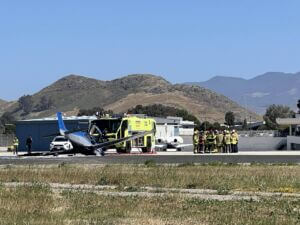 5:24 p.m. bound for Dallas-Fort Worth.
The flight was originally supposed to depart at 12:25 p.m.
___
UPDATE (4:33 p.m.) - The SLO County Airport will reopen Friday evening. Airport officials have announced that flights will begin landing and taking off once again starting at 5 p.m.
UPDATE (10:58 a.m.) - According to the Federal Aviation Administration (FAA), the Cirrus SR22 crashed on takeoff from the SLO County Airport at about 9:15 a.m. Just two people were on board.
The plane is registered to Yale Aviation LLC out of Ariel, Washington.
The FAA is investigating the crash.
___
(10:08 a.m.) - The SLO County Airport (SBP) has closed and emergency crews are responding after a single-engine plane crashed on the runway Friday morning.
In a post on X at 9:17 a.m., CAL FIRE San Luis Obispo (SLO) said that a plane was down at the airport with fire visible on the aircraft.
The agency's Airport Crash Rescue team responded to the scene to knock down the fire and check on injuries, according to CAL FIRE SLO.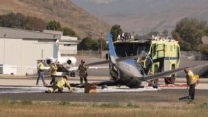
At 9:19 a.m., officials posted that two occupants were declining medical care and that the Airport Crash Rescue Team had canceled its response.
Authorities said one engine and a battalion chief remained on the scene at that time.
CAL FIRE SLO reported at 9:25 a.m. that the incident commander requested a hazmat response at the airport to mitigate 90 gallons of fuel.
SBP officials told KSBY that the airport is currently closed due to an "active event" at the facility.
Airport representatives added that passengers should check directly with their airlines for flight status updates.
https://www.ksby.com/san-luis-obispo/slo-county-airport-closed-following-plane-crash
Strong storms down trees, flip planes in soggy start to Memorial Day weekend in South Florida
By Jack Royer, Faith Graham, Kevin Boulandier
PEMBROKE PINES, FLA. (WSVN) - Nasty weather ripped through parts of South Florida, getting Memorial Day weekend off to a stormy start.
Many areas across Broward County saw the full force of Mother Nature on Friday with heavy rain, whipping winds and even flipped planes at North Perry Airport in Pembroke Pines. 
Airport officials said powerful winds sent parked aircraft flying, severely damaging several of them.
One plane was captured upside down. Another one was seen resting on top of a fuel truck.
Firefighters were seen working to get the plane dislodged, Friday night.
No injuries were reported.
Staff said the airport would be closed until 7 a.m. Saturday to give Broward County Aviation Department a chance to assess the damage left behind by the thunderstorm.
Near the airport, video captured by resident Eddie Flor shows hail pounding the ground in the area of Taft Street, between Hiatus Road and Palm Avenue.
The severe storms moved quickly during Friday afternoon’s rush hour.
A tree fell on a bus stop at University Drive and Pines Boulevard after strong winds uprooted it.
Surveillance video captured a massive tree that landed on the house after it was uprooted by the strong winds.
Renzo Gomez, who lives near where the downed tree landed, said he was spared the worst of the storm compared to his neighbors.
“Our screened porch got some holes from the hail, but nothing to the extent of this type of damage as we’re walking around, looking at what’s going on in our neighborhood,” he said.
Firefighters arrived at the scene to remove the tree from the home.
In Miramar, doorbell camera video shows one woman running for cover as the storms rolled into her area.
“Scary. Thank God nobody was hurt, but I have no fence right now, and this is my neighbor’s shed!” said Joana Klaiss.
A piece of that shed ended up tangled with the power lines.
Florida Power & Light crews worked late into the night to clean up the mess and restore power to all those affected.
Up north in Fort Lauderdale, after a stormy few hours, the city skyline was hidden underneath a blanket of storms before blue skies peeked back through in time for a sunset.
While some residents have speculated that a small tornado may have caused some of the damage across the area, the National Weather Service said there were no tornadoes. Instead, it was powerful straight line winds.
Firefighters respond to aircraft incident at Invermere airport
Members of the Windermere Fire Department responded to an isolated aircraft incident at the Invermere Airport on May 23.
“When we arrived on scene, we found a section of a small aircraft on fire and worked to get it fully extinguished,” said Thomas Dobbin, Assistant Chief with Columbia Valley Rural Fire and Rescue.
“We want to thank the two members of the Shuswap Band who immediately sprang into action with their water truck to ensure they got water on scene as quickly as possible.”
The aircraft had returned to the airport prior to the fire breaking out and there were no injuries.
Response included 10 members of the Windermere Fire Department along with 3 apparatus responded to the call, and both RCMP and BC Ambulance also attended as a precaution.
While the fire was extinguished, crews remained on site to ensure there were no hot spots. The cause of the fire has not been determined; however, it is not suspicious in nature.
1 killed, 1 severely burned in plane crash in Ashtabula County Sunday
by: Emily Smith
ASHTABULA COUNTY, Ohio (WJW) — One person is dead and another is hospitalized after a plane crash in Ashtabula County Sunday morning, the Ohio State Highway Patrol confirmed to Fox 8 News. 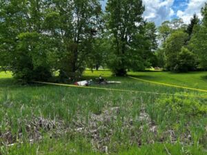
According to Lt. Timothy Grimm with the Ashtabula Post, the patrol received a call at 10:11 a.m. Sunday about a plane crash in the area of SR 307 in Harpersville Township.
The Ashtabula County Sheriff’s Office was first on scene and confirmed two people were onboard a Zenith 701 single-engine plane that went down not far from the Germack Airport in Geneva.
One person had already made it out of the plane and was walking around, Lt. Grimm said. The victim was severely burned and was taken to a hospital.
The other occupant was pronounced dead at the scene.
The names and ages of the victims have not been released.
“It’s a tragic event. There was a life lost in this event,” Lt. Grimm said.
It’s not clear where the plane was headed or coming from. The FAA and NTSB will assist in the investigation, Lt. Grimm said.
This isn’t the first plane crash in Northeast Ohio this month.
In early May, a pilot from West Lafayette, Indiana, was killed after his plane went down in Ashland County. And, on Sunday, an airplane crashed in Riley Township in Sandusky County.
https://fox8.com/news/first-responders-on-scene-of-reported-plane-crash-in-ashtabula-county/
Pilot airlifted to hospital after fiery plane crash at Cooking Lake Airport
By Karen Bartko Global News
A man was taken to hospital in Edmonton after a plane crashed and caught on fire southeast of the city at Cooking Lake Airport in Strathcona County. 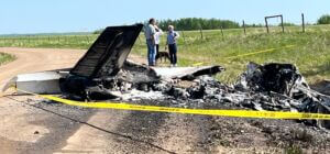
At 2:15 p.m. Monday, RCMP said officers from Strathcona County were at the scene of the small plane crash, which also resulted in a small grass fire.
The pilot was attempting to land when he lost control and the aircraft crashed.
Crews on scene told Global News the pilot was able to get out of the plane and make it to safety before it went up in flames, but he suffered some burns in the process.
STARS Air Ambulance said it airlifted a man in his 70s to the University of Alberta Hospital and AHS said he was in in serious, but stable condition.
About an hour later, RCMP said the grass fire had been put out by Strathcona County firefighters.
The Transportation Safety Board of Canada (TSB) said it was deploying a team of investigators to look into the crash involving the privately registered small aircraft.
No other details have been released.
https://globalnews.ca/news/11197909/cooking-lake-airport-plane-crash-may-2025/
Small helicopter crashes near Miami, one person killed
by Jamie Burch, ABC 7 News
ROBERTS COUNTY, Texas — A small helicopter crashed in Roberts County, killing one person.
It happened around 7:20 a.m. off FM 2699, about 7.5 northwest of Miami. 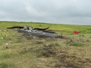
The pilot, Travis Chester, 31, of Miami, was the only person on board.
According to the NTSB, the helicopter is a 2014 Robinson R44 Raven II similar to the one pictured above.
The Robinson R44 Raven II is a light, four-seat, single-engine helicopter known for its versatility and affordability. It offers a range of up to 348 nautical miles and a top speed of 149 mph.
Chester had used the helicopter to round up cattle on his ranch.
The cause of the crash remains undetermined.
The National Transportation Safety Board (NTSB) and the Federal Aviation Administration (FAA) will investigate.
https://abc7amarillo.com/news/local/small-helicopter-crashes-near-miami-roberts-county-texas-one-person-killed-robinson-r44-raven-ii-ntsb-department-of-public-safety-single-engine
Report: DOGE Team Begins Reviewing NTSB
Department of Government Efficiency is evaluating operations at the federal investigative agency.
Caleb Revill
The Department of Government Efficiency (DOGE) has reportedly assigned a team to review operations at the National Transportation Safety Board. 
A Reuters report on Wednesday cited an unnamed NTSB spokesperson who confirmed that DOGE was evaluating the investigative agency.
DOGE has been assigned to review finances at several federal agencies since President Donald Trump’s inauguration. Elon Musk’s initiative to cut government spending first took aim at the aviation sector in the aftermath of January’s deadly midair collision in Washington, D.C.
Some agencies have cut staff following their DOGE visits, including the FAA in February.
A month after the FAA’s cuts, NTSB Chair Jennifer Homendy testified to the House Appropriations Committee that her agency had not yet seen any staffing changes. At the time, NTSB employed 427 people working on 1,250 active accident investigations across the U.S. and in Puerto Rico.
During her testimony, Homendy told Congress the agency would need between 485 and 500 workers to achieve full staffing. She requested additional funding for the 2026 fiscal year.
FLYING has reached out to NTSB for comment.
https://www.flyingmag.com/report-doge-team-begins-reviewing-ntsb/?oly_enc_id=3681J3205156A2X
NTSB Prelim: Cessna T207
Accident Pilot State(d), Over The Radio, “I’m Going Around, There’s Something On The Runway,” Just Before The Accident
Location: Nanwalek, AK Accident Number: ANC25FA035
Date & Time: April 28, 2025, 13:55 Local Registration: N91025
Aircraft: Cessna T207 Injuries: 2 Fatal, 1 Serious
Flight Conducted Under: Part 135: Air taxi & commuter - Scheduled
On April 28, 2025, about 1355 Alaska daylight time, a Cessna T207 airplane, N91025, was substantially damaged when it was involved in an accident near Nanwalek, Alaska. The pilot and one passenger were fatally injured. One passenger was seriously injured. The airplane was operated as flight number 213, a Title 14 Code of Federal Regulations Part 135 scheduled commuter air carrier flight.
According to the operator, Smokey Bay Air, the pilot and two passengers departed the Homer Airport, Homer, Alaska, en route to the Nanwalek Airport, Nanwalek with 40 gallons of aviation fuel on board, 271 lbs of passenger baggage, and 257 lbs U.S. mail on board. Archived Federal Aviation Administration (FAA) Automatic Dependent Surveillance-Broadcast (ADS-B) data shows the airplane departing Homer, crossing Kachemak Bay and following the coastline before approaching Runway 19 in Nanwalek from the North. The ADS-B track data then shows that, as the airplane approached Nanwalek Airport from the north, it momentarily sidestepped to the right of the runway centerline, which was followed by a left turn once it was parallel with the approach end of Runway 19. The airplane was about 100 ft above ground level (AGL) at the final ADS-B captured datapoint.
Multiple witnesses, located on the ground in the vicinity of the airport, reported seeing the airplane approaching Runway 19 for landing, from over the village. The witnesses then stated that the airplane increased throttle and entered a steep left bank near the North end of Nanwalek Airport before losing control and spiraling down to the ground. Some witnesses reported seeing a dog on the runway when the accident airplane was on final approach.
A pilot, in a second Smokey Bay Airplane a few miles in trail of the accident airplane also inbound to Nanwalek Airport, recalled hearing the accident pilot state, over the radio, “I’m going around, there’s something on the runway,” just before the accident. The surviving passenger was later interviewed at a hospital in Anchorage, Alaska. He reported approaching Nanwalek Airport from the village side and recalled that the airplane was offset to the right of runway centerline on final approach. He then stated that the airplane entered a sharp, steeper than normal, left banking turn before losing control and rapidly spiraling down to the surface.
The airplane came to rest on the beach about 350 ft northwest of the approach end of Runway 19. First responders subsequently pulled the airplane wreckage to higher ground to keep the airplane from becoming submerged as the tide began to rise.
The left wing was separated from the fuselage, held only by the control cables, and rotated forward of the main wreckage. The right wing exhibited spanwise deformation to the outboard section, beyond the lift strut, consistent with impact damage. Both the aft section of the fuselage, forward of the empennage, and the nose section of the fuselage, forward of the cockpit, exhibited damage consistent with rotational forces on impact.
During the onsite investigation, no preimpact anomalies were visually observed with the flight control system. The flap selector was found in the full down position. The three propeller blades exhibited rotational signatures.
The wreckage has been recovered to a secure facility for further examination.
FMI: www.ntsb.gov
NTSB Prelim: Diamond Aircraft Ind Inc DA 40 NG
Pilot Asked The Mechanic To Go For A Test Flight Around The Airport Traffic Pattern With Him For A Touch-And-Go Landing, And Then A Full-Stop Landing
Location: Sanford, NC Accident Number: ERA25LA198
Date & Time: May 7, 2025, 16:00 Local Registration: N499BW
Aircraft: Diamond Aircraft Ind Inc DA 40 NG Injuries: 2 Serious
Flight Conducted Under: Part 91: General aviation - Personal
On May 7, 2025, about 1600 eastern daylight time, a Diamond Aircraft DA 40 NG, N499BW, was substantially damaged when it was involved in an accident near Sanford, North Carolina. The pilot and passenger were seriously injured. The airplane was operated as a Title 14 Code of Federal Regulations Part 91 personal flight.
According to the passenger, who also served as the mechanic for the airplane, he completed the annual inspection on the airplane the week before the accident flight. He further stated that the pilot approached him on the day of the accident and asked him to check his gearbox oil level. The pilot stated it appeared to be lower than normal. The mechanic checked and found the oil plug gasket had a tear in it and replaced the gasket with a new one. He then cleaned and ran the engine to check for leaks. The engine check was good, and the pilot asked the mechanic to go for a test flight around the airport traffic pattern with him for a touch-and-go landing, and then a full-stop landing.
They departed runway 21 at Raleigh Executive Jetport at Sanford-Lee County Airport (TTA), Sanford, North Carolina. Runway 21 was 6,501 ft long, 100 ft wide, and consisted of asphalt. They circled around to perform a touch-and-go landing on runway 21; however, before landing the pilot decided to do a “go around” and leveled off the airplane above the runway. As they were flying down the runway, the engine “popped” like a “backfire” and the pilot tried to land on the remaining runway. They were going too fast and did not have enough runway length left. The pilot bounced the airplane twice and said they were going to go around. The pilot applied engine power, and the mechanic heard the engine rpm increase. Then the pilot turned the airplane left and they “fell” and impacted the ground. He did not recall anything after that.
Due to his injuries, the pilot was unable to provide a statement. The wreckage has been retained for further examination.
FMI: www.ntsb.gov
NTSB Prelim: Cessna 525
The Airplane Began A Descent While Still In A Right Turn And Impacted Terrain
Location: Mesquite, TX Accident Number: CEN25FA119
Date & Time: March 13, 2025, 07:33 Local Registration: N525CZ
Aircraft: Cessna 525 Injuries: 1 Fatal
Flight Conducted Under: Part 91: General aviation - Positioning
On March 13, 2025, about 0733 central daylight time, a Cessna 525A airplane, N525CZ, was destroyed when it was involved in an accident near Mesquite, Texas. The pilot was fatally injured. The airplane was operated under the provisions of Title 14 Code of Federal Regulations Part 91 as a positioning flight.
According to the airplane’s owner, the pilot intended to depart the Mesquite Metro Airport (KHQZ), Mesquite, Texas, and was en route to Addison Airport (KADS), Dallas, Texas, to pick up passengers, and continue on to an undetermined destination. The fixed based operator manager at KHQZ stated that the pilot requested a fuel top off before departure, and the airplane was fueled with 224 gallons of Jet-A fuel.
The KHQZ tower controller stated that the airplane was cleared to KADS via a left downwind departure which would have involved a left climbing turn on departure. ADS-B flight track data showed that after the airplane departed to the south from runway 18, at 0733:21, it entered a right turn and climbed to about 950 ft mean sea level, or about 500 ft above ground level. At 0733:45, the airplane began a descent while still in a right turn and impacted terrain. A postimpact fire ensued. The last recorded point was at 0733:52, with an estimated flight time of 31 seconds.
The pilot was in radio communications with the tower controller at KHQZ, and no distress calls were received from the pilot. Witnesses reported they saw the airplane in a descending, right bank turn. There were no reports of fire or smoke trailing the airplane.
The airplane impacted a heavily wooded area with several winding creeks to the southsouthwest of KHQZ. The airplane was fragmented, and the debris path was about 450 ft in length, oriented on a magnetic heading of 270°. A postimpact fire consumed portions of the airplane. All major components were located in the debris path.
The airplane was equipped with a cockpit voice recorder (CVR). The CVR was recovered from the empennage section of the airplane and was sent to the National Transportation Safety Board Vehicle Recorders Laboratory, Washington, DC, for processing and readout. In addition, the airplane’s engines were equipped with Full Authority Digital Engine Control (FADEC) modules which were located and shipped to the manufacture’s facility for data download. The wreckage was recovered from the accident site and transported to a secure location for further examination.
According to information on file with the Federal Aviation Administration, the pilot held a commercial pilot certificate with ratings for airplane single-engine land, airplane multi-engine land, and instrument airplane. He had several type ratings including one for single pilot operations of a Cessna 525, issued on December 16, 2018. On his most recent application for medical certificate, dated December 8, 2023, the pilot reported he had flown about 6,800 total hours, and listed his occupation as a self-employed pilot.
FMI: www.ntsb.gov
NTSB Prelim: Cessna 172RG
Pilot Described The Loss Of Power As A Smooth Reduction Of Power To Idle
Location: Louisburg, NC Accident Number: ERA25LA188
Date & Time: April 23, 2025, 17:03 Local Registration: N6386V
Aircraft: Cessna 172RG Injuries: 2 None
Flight Conducted Under: Part 91: General aviation - Personal
On April 23, 2025, about 1703 eastern daylight time, a Cessna 172RG, N6386V, was substantially damaged when it was involved in an accident near Louisburg, North Carolina. The commercial pilot and passenger were not injured. The airplane was operated as a Title 14 Code of Federal Regulations Part 91 personal flight.
The pilot reported that he performed a preflight inspection of the airplane. During the inspection, he found water while sampling fuel from the fuel tanks. The pilot continued to sample fuel from the fuel tanks until no more water was found. He then rocked the wings to release any trapped water and sampled fuel from the fuel tanks again until there was no water found. He reported that the wing fuel tanks were about half full of fuel.
The engine start and run-up were normal, with no abnormalities noted by the pilot. About 1702, the pilot entered the runway and applied full power for takeoff. With all engine indications normal, he released the brakes and began the takeoff roll. When the airplane reached an airspeed of 55 knots, the pilot increased the airplane’s pitch attitude and began climbing out at an airspeed 70 knots. When no usable runway remained, the pilot selected the landing gear to the up position, and he reported “the moment the landing pump switched on the engine lost power.”
The pilot described the loss of power as a smooth reduction of power to idle, where the engine stayed. He selected the landing gear to the down position, reduced the throttle control, and attempted to land on the remaining runway and runoff area. After realizing he could not, he attempted to glide over an airport perimeter fence. During the glide, he applied full throttle, and the engine revved to about 1,900 rpm before reducing uncommanded again to idle. The landing gear impacted the perimeter fence, the horizontal stabilizer impacted a fence pole, and the airplane impacted a road near the airport perimeter, sliding off the road and into a field. The horizontal stabilizer sustained substantial damage during the accident sequence.
The wreckage was retained for further examination.
FMI: www.ntsb.gov

Today in History
48 Years ago today: On 27 May 1977 Aeroflot flight 331, an Ilyushin Il-62M, crashed while on approach to Havana-José Martí Airport, Cuba, killing 67 occupants; 2 survived the accident.
| Date: | Friday 27 May 1977 |
| Time: | 08:45 |
| Type: | Ilyushin Il-62M |
| Owner/operator: | Aeroflot, International Civil Aviation Directorate |
| Registration: | CCCP-86614 |
| MSN: | 51903 |
| Year of manufacture: | 1975 |
| Total airframe hrs: | 5549 hours |
| Cycles: | 1144 flights |
| Engine model: | Soloviev D-30KU |
| Fatalities: | Fatalities: 67 / Occupants: 69 |
| Other fatalities: | 0 |
| Aircraft damage: | Destroyed, written off |
| Category: | Accident |
| Location: | 1,3 km SW of Havana-José Martí International Airport (HAV) - Cuba |
| Phase: | Approach |
| Nature: | Passenger - Scheduled |
| Departure airport: | Lisboa-Portela de Sacavém Airport (LIS/LPPT) |
| Destination airport: | Havana-José Martí International Airport (HAV/MUHA) |
| Confidence Rating: | Information is only available from news, social media or unofficial sources |
Narrative:
Aeroflot flight 331, an Ilyushin Il-62M, crashed while on approach to Havana-José Martí Airport, Cuba, killing 67 occupants; 2 survived the accident.
Flight SU331 departed Moscow-Sheremetyevo Airport on a scheduled service to Havana, Cuba, with en route stops at Frankfurt, Germany and Lisbon, Portugal. After the crew change, the flight took off from Lisbon at 03:32 UTC.
The en route part of the flight was uneventful. Descending towards Havana, the flight was vectored for an approach to runway 05. The aircraft turned onto runway heading at a distance of 9 km from the runway threshold. According to the approach procedure, the aircraft should have done so at 14-15 km from the threshold. During the approach the flight crew encountered a local fog bank. With the runway not in sight, the aircraft descended below the decision height of 150 m. At that point the aircraft was 3 km from the runway threshold.
The flight crew had not set their altimeters to the airfield pressure (QFE) of 752 mm Hg. This caused the aircraft to be lower than indicated.
At a distance of 1,820 meters from the runway the aircraft hit power lines, causing the aircraft to bank 70° to the right. The aircraft cut the tops of 22 palm trees, passed across a canal and impacted wasteland terrain 1270 m short of the runway and 121 m to the right of the extended centreline.