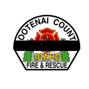
We start the week with an update from Chief Goldfeders "The Secret List" to the tragic story out of Coeur d’Alene, Idaho where 2 Firefighters were murdered by a sniper who ambushed them as they responded to a brush fire near near Coeur d’Alene.
Our thoughts, prayers and condolences to the families of these Firefighters as well as our Brothers and Sisters of both the Coeur d’Alene FD and the Kootenai County FR. Departments.
May they Rest in Peace...
We also pray for at least one other Firefighter was out of surgery at a Coeur d'Alene hospital late Sunday-critical but stable condition.
Now here are the stories for today...
Be safe out there!
Tom
Latest Update: IDAHO LODD’s & Radio Audio (The Secret List)
All,
Here are the latest updates as of 0030 hours eastern following the press conference.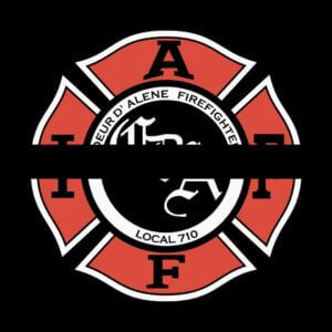
- Two Firefighters were shot and killed as they responded to that brush fire near Coeur d’Alene, Idaho. At least one other Firefighter was out surgery at a Coeur d'Alene hospital late Sunday-critical but stable. The injured and fallen have not yet been identified.
- One Firefighter who was killed was from Coeur d’Alene FD and the other one was from Kootenai County FR.
- The fire appeared to have been
 intentionally set as part of an "ambush," and unsuspecting Firefighters and later arriving Sheriff’s deputies took active sniper fire.
 - Shortly before 2100 local time a man was found dead on Canfield Mountain with a gun nearby. A shelter-in-place order issued this afternoon was lifted as part of the announcement.
- Canfield Mountain is in Coeur d’Alene, which is in northwestern Idaho, about 30 miles from Spokane, Washington
 intentionally set as part of an "ambush," and unsuspecting Firefighters and later arriving Sheriff’s deputies took active sniper fire.
Here is a link to the dispatch, arrival, size up and ambush.
Idaho Shooting Radio Traffic.MP4
Much more to follow.
Take Care. Be Careful. Pass It On.
BillyG
The Secret List 6-30-2025-0047 Hours

Small plane crashes behind Ohio home: authorities
by: Sarah DeLisio
HOWLAND, Ohio (WKBN) — Authorities,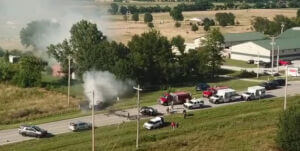 including the local coroner, are on the scene after a small plane reportedly crashed behind an Ohio home early Sunday morning.
According to the Ohio State Highway Patrol, the crash happened around 7 a.m. ET along King Graves Road NE in Howland, about 55 miles east of Akron. The National Transportation Safety Board (NTSB) said the plane was a twin-engine Cessna 441.
Howland Fire Chief Ray Pace said the 911 caller reported hearing a large explosion behind her home and seeing flames.
Smoke could be seen rising from the area via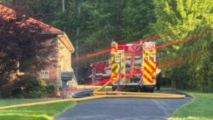 a weather camera from the nearby Youngstown/Warren Regional Airport. According to Pace, the plane crashed in a wooded area behind the home.
Nexstar’s WKBN reported seeing crime scene tape in the area, as well as crews using a drone, the Trumbull County HAZMAT team, and a local power company.
Multiple roads in the area have also been closed.
No additional details were immediately available.
Andrew Peterson contributed to this report.
https://www.fourstateshomepage.com/news/small-plane-crashes-behind-ohio-home-authorities/
2 injured in plane crash on Kelleys Island
The Erie County Sheriff's Office says a privately owned single-engine plane crashed late Friday morning.
Author: Troy Gingerich (WTOL)
KELLEYS ISLAND, Ohio — Two people were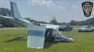 injured following a plane crash at Kelleys Island Municipal Airport late Friday morning, according to the Ohio State Highway Patrol.
OSHP said a 69-year-old pilot and a 67-year-old passenger from Liberty Township on board the privately owned single-engine plane were flown to the hospital with non-life-threatening injuries.
According to OSHP, the Cessna 177 Cardinal was taking off to the west just before 11:30 a.m. and crashed right after takeoff. OSHP said the plane crashed into the ground and no other properties were damaged in the crash.
According to the sheriff's office, Kelleys Island police, fire and EMS responded to the scene.
The Kelleys Island police chief says the National Transportation Safety Board (NTSB), Federal Aviation Administration (FAA) and OSHP are investigating the crash.
https://www.wtol.com/article/news/local/two-injured-in-plane-crash-kelleys-island/512-9f090b50-91d4-4c32-85fe-2ae25a93e65f
1 killed in plane crash at Ottawa Executive Airport
by: Corinne Moore, Anna Skog
ZEELAND TOWNSHIP, Mich. (WOOD) — A man was killed in a plane crash at Ottawa Executive Airport on Sunday morning.
Around 10:50 a.m., deputies with the Ottawa County Sheriff’s Office were sent to the Ottawa Executive Airport, located at 5923 Byron Rd, after receiving reports about a plane crash.
Responding deputies found a small fixed-wing aircraft with heavy damage just off the runway.
The lone occupant died, the sheriff’s office said. An airport official confirmed the victim was a man from Ottawa County but did not identify him or provide his age.
It’s unclear what led up to the crash. The investigation is being turned over to the FAA, the sheriff’s office said.
Friends and family kept reaching out to Austin Bonnema, a pilot training to be a commercial pilot. He was flying out of Ottawa Executive to Ludington Sunday to get his training hours in.
“We’re on the way here and I got a call from my brother saying that there was a plane crash at the airport and he was actually wanting to see if it was us,” Bonnema said.
People were also calling instrument-rated pilot and mechanic Luke Koeman for the same reason. He was flying back to Ottawa Executive from Ohio when he saw the remains of the crash, which he described as a “crumpled up wreck.” As a mechanic, Koeman has seen crashes before, but this he said was the worst.
“It was absolutely gut-wrenching. … I’ve seen my share of incidents and aviation industry that one’s pretty. That’s the worst one I’ve ever seen,” Koeman said.
https://www.woodtv.com/news/ottawa-county/1-killed-in-plane-crash-at-ottawa-executive-airport/
Two planes collided at Noi Bai airport
VN Express
Hanoi While moving on the taxiway at Noi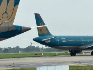 Bai airport, a Vietnam Airlines plane hit the tail of another plane of the same airline on June 27.
At 2 p.m., Boeing aircraft numbered VN-A863 taxied onto the runway to prepare for takeoff to Ho Chi Minh City. When reaching the intersection of taxiways S3 and S, the Boeing hit the tail of Airbus aircraft numbered VN-A338 waiting to take off to Dien Bien, according to the Northern Airports Authority.
As a result, the Boeing suffered damage to the right wing tip, and the Airbus suffered a torn vertical wing. There were some debris from both vehicles at the scene.
The two planes had to stop operations for technical inspection. At the time of the collision, there was no rain in the Noi Bai area and the light ensured good visibility.
The flight to Dien Bien had 127 passengers, the flight to Ho Chi Minh City had 259 people. All passengers and luggage were brought back to Terminal T1. Vietnam Airlines arranged for passengers to transfer to an alternative flight.
Authorities inspected the scene, pulled the two aircraft to a safe parking position, cleared and cleaned taxiways S and S3. Airport operations continued as normal.
The leaders of the Civil Aviation Authority of Vietnam said they are coordinating with relevant parties to assess and verify the cause of the incident. Initial findings show that the Airbus preparing to depart for Dien Bien did not park at the correct waiting stop on taxiway S3.
https://vnexpress.net/hai-may-bay-va-cham-tai-san-bay-noi-bai-4907232.html
Pilot walks away with just minor injuries after weekend crash
News/Talk 989 WORD
Disaster and death were thankfully avoided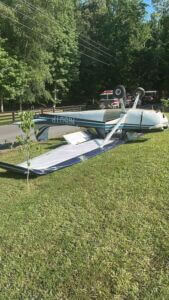 after a weekend plane crash in the Upstate. Firefighters and emergency personnel responded just after 9AM Sunday to a home on Williams Road in Pelzer.
The plane landed upside down in the crash. Officials say nobody died in the crash and the pilot was the only one aboard the plane. The pilot suffered what were described as minor injuries.
The reason for the crash has not been released, as of this time and no further details are available.
https://www.audacy.com/989word/news/local/pilot-suffers-just-minor-injuries-after-weekend-crash
MPD: Small plane crashes in Frayser; no injuries reported
by: Raven Moore
MEMPHIS, Tenn. — Memphis Police are on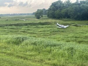 the scene in Frayser after a small plane crash.
At 4:53 p.m., officers responded to a plane crash in a field south of the General DeWitt Spain Airport located at 2787 N. 2nd St.
According to officials, the aircraft carrying two passengers landed in the field around 4:30 p.m.
Fortunately, no injuries have been reported.
At this time, there is no word on what led to the crash, but the FAA is coordinating an investigation into this incident.
https://wreg.com/news/mpd-small-plane-crashes-in-frayser-no-injuries-reported/
2 killed in small plane crash in Capron, Illinois
By Todd Feurer
Two people were killed in a small plane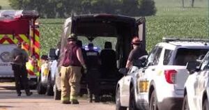 crash Saturday afternoon in Boone County in northern Illinois.
Boone County Sheriff Scott Yunk said, around 3:20 p.m., deputies responded to a report of a plane crash in a corn field near Capron and Blaine roads in Capron, Illinois, about 90 miles northwest of Chicago, near the Wisconsin state line.
When the first deputies arrived on scene, a farmer helped them locate the plane. Both people inside the plane were killed in the crash, but they have not yet been identified.
Yunk said it remains unclear where the plane took off, or where it was headed.
The National Transportation Safety Board confirmed it is investigating the crash, which involved a Vans RV-10 single-engine propeller plane.
The plane is registered in Grayslake, Illinois, about 45 miles east of Capron, according to Federal Aviation Administration records.
https://www.cbsnews.com/chicago/news/plane-crash-capron-illinois-boone-county/
NTSB Final Report: ICON A5
Pilot’s Failure To Maintain Clearance From The Water While Flying At A Low Altitude
Location: Onamia, Minnesota Accident Number: CEN23FA270
Date & Time: June 30, 2023, 13:49 Local Registration: N239BA
Aircraft: ICON A5 Aircraft Damage: Destroyed
Defining Event: Controlled flight into terr/obj (CFIT) Injuries: 1 Fatal
Flight Conducted Under: Part 91: General aviation - Personal
Analysis: The flight of two airplanes was in cruise flight on a north heading about 50 ft above a lake when the pilots agreed to fly closer to the west shore of the lake. The pilot of the second (non-accident) airplane initiated a climb and turned toward the west. In his peripheral vision, he noticed a splash and thought the pilot of the amphibious light sport airplane had landed on the water. He made several radio calls to the accident pilot with no response.
A witness reported seeing both airplanes fly about 30–40 ft above the surface of the water; however, they did not see the accident. The airplane was destroyed when it impacted the water and became submerged in about 26 ft of water. Examination of the wreckage indicated that the airplane impacted water in a left-wing-low attitude. Further examination revealed no evidence of preimpact failures or malfunctions that would have precluded normal operation. Damage to the propeller indicated that the engine was likely under power at the time of the accident.
The pilot’s autopsy revealed cardiovascular disease that would have increased his risk of experiencing a sudden impairing or incapacitating cardiac event, such as arrhythmia, chest pain, or heart attack. There was no autopsy evidence that such an event occurred; however, such an event does not leave reliable autopsy evidence if it occurs shortly before death. Toxicology results indicated that the pilot had used a cannabis product. However, the precise timing of his last cannabis use, and whether it caused significant impairing effects at the time of the accident, could not be determined from the measured levels of delta-9-THC and its metabolites.
Probable Cause and Findings: The National Transportation Safety Board determines the probable cause(s) of this accident to be -- The pilot’s failure to maintain clearance from the water while flying at a low altitude.
FMI: www.ntsb.gov
NTSB Final Report: Cirrus SR22
Aircraft Parachute System (CAPS) Was Deployed About 293 Ft Above Ground Level, Which Was Too Low To Allow For Full Deployment Of The Parachute System
Location: Jamestown, New York Accident Number: ERA23FA258
Date & Time: June 6, 2023, 13:52 Local Registration: C-GNMT
Aircraft: Cirrus SR22 Aircraft Damage: Destroyed
Defining Event: Loss of control in flight Injuries: 2 Fatal
Flight Conducted Under: Part 91: General aviation - Instructional
Analysis: The day before the accident, the pilot and the flight instructor brought the airplane to a maintenance facility due to a low engine manifold air pressure (MAP) indication. The owner of the maintenance facility adjusted the MAP via a set screw on the bottom of the slope controller (turbocharger controller), while the instructor performed ground runs to verify it. The instructor then took a facility maintenance technician on a 30-minute post-maintenance flight. There were no anomalies noted during that flight.
On the day of the accident, the pilot and instructor flew a cross-country flight to the destination airport. Recorded data indicated that, during the flight, the MAP momentarily exceeded the maximum value of 37.5 in (37.59 in) for 1 second, which activated a red crew alerting system (CAS) message visual warning; however, there were no further exceedances during the flight. After conducting business at the destination, the pilot and instructor boarded the airplane for the return flight. They conducted one uneventful touch-and-go landing when, following the second touch-and-go, about midfield at 200 ft above ground level, the MAP exceeded 38.5 in (39.91 in), which activated an aural CAS warning, and the fuel flow exceeded 41 gph (49.5 gph); however, the engine’s fuel-to-air ratio remained sufficient, and the engine continued to operate. The airplane subsequently pitched up 13° and rolled left 67° just before the Cirrus Aircraft Parachute System (CAPS) was deployed about 293 ft above ground level, which was too low to allow for full deployment of the parachute system. The airplane impacted terrain and was consumed by a postimpact fire.
Subsequent examination of the slope controller did not reveal any preimpact mechanical malfunctions; however, it sustained heat damage due to a postcrash fire and its gasket rubber diaphragm were destroyed consistent with heat damage. Examination of the remainder of wreckage also did not reveal any preimpact mechanical malfunctions. Based on the evidence, the pilot(s) likely overreacted to a distracting anomaly in the cockpit (exceedance of MAP, resulting in an aural cockpit CAS warning), lost control of the airplane, and deployed the CAPS at altitude that was insufficient for it to be effective.
Probable Cause and Findings: The National Transportation Safety Board determines the probable cause(s) of this accident to be -- The pilots’ failure to maintain airplane control following an anomalous engine indication during the initial climb, which resulted in a loss of control and parachute deployment at an altitude too low for the system to operate effectively. Contributing to the accident was an exceedance of engine manifold air pressure for reasons that could not be determined based on the available evidence.
FMI: www.ntsb.gov
NTSB Final Report: Rutan Long-EZ
He Attempted To Restart The Engine Three Times. On The Third Restart Attempt, He Noticed That Flames Were Coming Out From The Right Wing Near The Fuel Cap
Location: Sparta, Illinois Accident Number: CEN25LA090
Date & Time: February 1, 2025, 13:50 Local Registration: N88LE
Aircraft: Rutan Long-EZ Aircraft Damage: Destroyed
Defining Event: Fire/smoke (non-impact) Injuries: 1 None
Flight Conducted Under: Part 91: General aviation - Personal
Analysis: The pilot reported that he taxied to the runway and performed an engine runup. During the runup, the pilot noticed that one of the magnetos was not operating properly, so he started to taxi back to his hangar. While taxing back to the hangar, he smelled burning wire insulation, and shortly after the engine stopped. He attempted to restart the engine three times. On the third restart attempt, he noticed that flames were coming out from the right wing near the fuel cap. He immediately exited the airplane and called the fire department. The airplane was destroyed by the fire.
Due to the damage caused by the fire, an examination of the airplane components to determine the source of the fire was not possible.
Probable Cause and Findings: The National Transportation Safety Board determines the probable cause(s) of this accident to be -- An onboard fire for unknown reasons.
FMI: www.ntsb.gov

Today in History
69 Years ago today: On 30 June 1956 TWA flight TW2, a Lockheed L-1049 Super Constellation and United Airlines flight UA718, a Douglas DC-7, crashed following mid-air collision over Grand Canyon, Arizona, USA, killing all 70 and 58 occupants on board both aircraft.
| Date: | Saturday 30 June 1956 |
| Time: | 10:32 |
| Type: | Lockheed L-1049-54-80 Super Constellation |
| Owner/operator: | Trans World Airlines - TWA |
| Registration: | N6902C |
| MSN: | 4016 |
| Year of manufacture: | 1952 |
| Total airframe hrs: | 10519 hours |
| Fatalities: | Fatalities: 70 / Occupants: 70 |
| Other fatalities: | 58 |
| Aircraft damage: | Destroyed, written off |
| Category: | Accident |
| Location: | Grand Canyon, AZ - United States of America |
| Phase: | En route |
| Nature: | Passenger - Scheduled |
| Departure airport: | Los Angeles International Airport, CA (LAX/KLAX) |
| Destination airport: | Kansas City Downtown Municipal Airport, MO (MKC/KMKC) |
| Investigating agency: | CAB |
| Confidence Rating: | Accident investigation report completed and information captured |
Narrative:
TWA flight TW2, a Lockheed L-1049 Super Constellation and United Airlines flight UA718, a Douglas DC-7, crashed following mid-air collision over Grand Canyon, Arizona, USA, killing all 70 and 58 occupants on board both aircraft.
TWA Flight 2, a Lockheed L-1049 Super Constellation, took off from Los Angeles (LAX) at 09:01 PST for an IFR flight to Kansas City (MKC). After reporting "on top" of the clouds at 2400 feet the crew contacted Los Angeles ARTCC. Clearance was given to climb to 19000 feet. Immediately thereafter TWA 2 asked for a routing change to Daggett via Victor Airway 210, This was approved. At 09:21 Flight 2 reported that it was approaching Daggett and requested a change in flight plan altitude assignment from 19,000 to 21,000 feet. The request was not approved because of traffic at FL210 (United Flight 718). A request for 1000 on top was granted. At 09:59 Flight 2 reported its position through company radio at Las Vegas. It reported that it had passed Lake Mohave at 09:55, was 1,000 on top at 21,000 feet, and estimated it would reach the 321-degree radial of the Winslow omni range station (Painted Desert) at 10:31. This was the last radio communication with the flight.
United Flight 718, a DC-7, had departed from Los Angeles at 09:04 for an IFR flight to Chicago cruising at FL210. At approximately 09:58 United 718 made a position report to the CAA communications station located at Needles. This report stated that the flight was over Needles at 09:58, at 21,000 feet, and estimated the Painted Desert at 10:31.
Both aircraft were at the same altitude on an intersecting course over Grand Canyon. United 718 was heading 46 degrees Magnetic and TWA 2 was heading 59 degrees Magnetic. Both aircraft collided in mid-air. First contact involved the centre fin leading edge of the Constellation and the left aileron tip of the DC-7. The lower surface of the DC-7 left wing struck the upper aft fuselage of the L-1049 with disintegrating force. The collision ripped open the fuselage of the Constellation from just forward of its tail to near the main cabin door. The empennage of the L-1049 separated almost immediately. The plane pitched down and fell to the ground. Most of the left outer wing of the DC-7 had separated and aileron control was restricted, causing the plane fell to the ground out of control.
PROBABLE CAUSE: "The pilots did not see each other in time to avoid the collision. It is not possible to determine why the pilots did not see ach other, but the evidence suggests that it resulted from any one or a combination of the following factors: 1) Intervening clouds reducing time for visual separation; 2) Visual limitations due to cockpit visibility, and; 3) Preoccupation with normal cockpit duties; 4) Preoccupation with matters unrelated to cockpit duties such as attempting to provide the passengers with a more scenic view of the Grand Canyon areal; 5) Physiological limits to human vision reducing the time opportunity to see and avoid the other aircraft, or; 6) Insufficiency of en-route air traffic advisory information due to inadequacy of facilities and lack of personnel in air traffic control."
![]()