We close out the week with the following stories...
Of note, congratulations to Chief Wainscott and his team at the Lexington, Kentucky Blue Grass Airport’s Regional Aircraft Rescue & Firefighting Training Center as they officially celebrated the grand opening of their newly expanded facility yesterday!
Here are the stories...
Have a safe weekend!
Tom
-
Pilot Seriously Injured After Plane Crash In Unadilla Township
Jessica Mathews / news@whmi.com
A small single-engine aircraft crashed and caught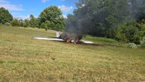 fire at the southern end of Richmond Field in Unadilla Township Thursday afternoon.
It happened shortly before 4pm.
Livingston County Central Dispatch received a crash detection notification from an iPhone and then calls from nearby residents.
Unadilla Township Police report the pilot was found outside the aircraft and had sustained significant injuries.
The pilot was a 22-year-old Ohio man flying from Charlevoix to Toledo.
Agencies that responded included the Unadilla Township Police Department, Pinckney Police Department, Livingston County Sheriff’s Department, Unadilla Township Fire Department, Putnam Township Fire Department, and Livingston County Ambulance.
The pilot was transported by ambulance to the University of Michigan Hospital.
The cause of the crash is unknown and remains under investigation by Unadilla Township Police, the FAA and NTSB.
Anyone who may have witnessed or heard the crash is asked to contact the Unadilla Township Police Department at 734-498-2325.
https://www.whmi.com/news/article/unadilla-plane-crash-richmond-field-pilot-injured
3 people in plane crash at Qualicum Beach Airport walk away injury-free
by Liz Brown
An investigation is underway after a plane crash occurred at the Qualicum Beach Airport Thursday, with occupants walking away, injury-free.
Qualicum Beach Fire Chief, Peter Cornell told CHEK News that crews responded to the incident at 3 p.m. Thursday.
Three people were inside the single-engine plane when the crash occurred.
“Everybody walked away,” says Cornell.
While the crash is still being investigated Cornell says there was an issue with the landing gear.
“One of the landing gear had collapsed and was sitting on the side of the runway slightly damaged,” he says.
“We don’t know what happened…it basically came to an abrupt landing on the side of the runway.”
BC Emergency Health Services (BCEHS) says received the call about the small aircraft crash at the Qualicum Airport just after 3 p.m. Thursday.
BCEHS initially responded with “two ground ambulances, one with Primary Care Paramedics and one with Advanced Care Paramedics, as well as an Air Ambulance,” BCEHS spokesperson Bowen Osoko told CHEK.
“Further updates indicated that there were no reported injuries, and one ground ambulance continued to the call out of an abundance of caution.”
While the other ambulances were returned to serve other calls, Osoko says paramedics assessed the three patients.
“Paramedics evaluated the potential patients who did not require further emergency medical treatment. No one required transport to hospital,” said BCEHS spokesperson Bowen Osoko.
Cornell says the Qualicum Beach Airport was closed for roughly four hours and is estimated to reopen by approximately 7 p.m.
CHEK has contacted RCMP, the Qualicum Beach Airport and the Transportation Safety Board for a response.
https://cheknews.ca/3-people-in-plane-crash-at-qualicum-beach-airport-walk-away-injury-free-1275312/
Plane makes an emergency landing after engine failure in Wayne County
A pilot had a rough landing in a cow pasture after a mechanical issue was reported Thursday evening in Palmyra Township.
Author: Yolany Maldonado
WAYNE COUNTY, Pa. — Crews responded to a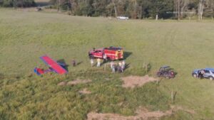 scene after a plane made an emergency landing Thursday evening in Wayne County.
According to White Mills Fire and EMS Chief Lucas Batzel, the pilot was the only person aboard the plane. The plane had a rough landing in a cow pasture after a reported engine failure just before 6 p.m., approximately 800 yards from the runway of Cherry Ridge Airport.
The pilot was not injured. PSP Honesdale reports that the plane had minor damages.
The FAA was notified, according to state police.
Blue Grass Airport’s Regional Aircraft Rescue & Firefighting Training Center Opens Newly Expanded Facility
Lauren Simmerman - Community Relations Manager - Blue Grass Airport
August 28, 2025—Today, Blue Grass Airport’s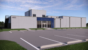 Regional Aircraft Rescue & Firefighting (ARFF) Training Center celebrated a recent 4,200 square foot expansion of its facility with an Open House showcasing new interior and exterior enhancements. As one of only a few Federal Aviation Administration (FAA)-designated training centers nationwide, the training center offers basic and advanced ARFF training for professionals. This expansion provides an upgraded experience for both the firefighters and instructors, as well as allows for larger class sizes to accommodate a growing number of participants.
Improvements to the facility totaled $4.8 million and included upgrades to the existing classroom and training areas, as well as entirely new spaces for apparatus, storage and cleaning. The modernized and expanded classroom now accommodates class sizes up to 30 participants and features updated technology in a more comfortable environment. The building expansion provides dedicated areas for equipment and fire gear storage, an apparatus bay, a personal protective equipment training area and a gear cleaning/washroom. These upgrades improve the firefighters’ experience, provide instructors with the necessary tools to deliver enhanced training and better prepare participants for the unique challenges of aircraft firefighting.
“We are proud to celebrate the completion of our expanded training center, which not only enhances the resources available to class participants but also provides modern amenities to make their training time more comfortable and productive,” said Eric Frankl, president & CEO of Blue Grass Airport. “This investment reflects the commitment of the FAA and Blue Grass Airport to delivering excellent training while ensuring participants have the facilities necessary to learn and collaborate.”
These renovations build upon the new training simulators that were installed in 2024. These simulators, including a plane modeled after a Boeing 737 and Airbus A320, and a 30-foot-long helicopter modeled after a UH-60 Blackhawk, expand the training center’s ability to offer a wider variety of classes and instruction.
Blue Grass Airport’s Regional Fire Training Center, established in 1997, is one of only 12 airport-operated training centers in the United States and provides top-tier education for ARFF professionals at Blue Grass Airport and airports of all sizes across the country. Designated by the Federal Aviation Administration as a regional training site, the center plays a vital role in preparing aircraft rescue and firefighting professionals from across the nation. Each year, the airport hosts more than 1,000 firefighters representing over 125 public safety departments from more than 30 states and several Canadian provinces. Offering a full spectrum of basic and advanced courses—from intensive weeklong training to annual recertifications—the facility also serves as a valuable resource for Blue Grass Airport’s own fire department.
NTSB Prelim: Piper PA46-500TP
The Airplane Suddenly Pitched Down To A Descent Rate Of -1600 Feet Per Minute
Location: Lititz, PA Accident Number: ERA25FA272
Date & Time: July 20, 2025, 08:00 Local Registration: N819MA
Aircraft: Piper PA46-500TP Injuries: 1 Fatal
Flight Conducted Under: Part 91: General aviation - Personal
On July 20, 2025, about 0800 eastern daylight time, a Piper PA-46-500TP Meridian airplane, N819MA, was substantially damaged when it was involved in an accident in Lititz, Pennsylvania. The pilot was the sole person on board and was fatally injured. The airplane was operated as a Title 14 Code of Federal Regulations Part 91 personal flight. Prior to the accident flight, the airplane was towed from its hangar by line service personnel and the fuel tanks topped off with 74 gallons of Jet A and Prist fuel additive, for a total of approximately 170 gallons. Shortly afterward, airport surveillance video showed the instrument-rated private pilot arriving at the airplane. He performed a brief preflight inspection of the airplane, then entered the airplane and closed the main cabin door.
The engine was started and preliminary air traffic control (ATC) data showed that the pilot called for his instrument flight rules (IFR) clearance from Lancaster Regional Airport (LNS), Lancaster Pennsylvania to State College Regional Airport (UNV), State College Pennsylvania. The readback of the clearance instructions to the clearance controller was correct and the pilot was cleared to taxi to the runway. Upon arrival at the hold-short line for departure, the ATC recording indicated that the tower controller advised the pilot to hold short while they waited for his IFR release. Three minutes later, the release was received, and the pilot was cleared for takeoff with a left turn on course.
There was no readback of this instruction, and the surveillance video showed the pilot enter the runway and start his takeoff roll. Preliminary Automatic Dependent Surveillance-Broadcast (ADS-B) data showed that the airplane reached rotation speed and lifted off. As the airplane cleared the departure end of the runway, having climbed to 650 ft mean sea level at a ground speed of 136 knots, the airplane suddenly pitched down to a descent rate of -1600 feet per minute. Approximately 9 seconds later, the airplane impacted a corn field 1/4 mile from the end of the runway on an estimated heading of 070° and a descent angle of approximately 39°and the left wing slightly down. The estimated flight time from the moment the wheels left the runway to impact was approximately 20 seconds. Nineteen seconds after takeoff, the control tower attempted to establish communication with the pilot multiple times without result.
The airplane came to rest 164 ft beyond the point of impact. The airframe was compressed due to impact forces. The engine and propeller created an impact crater 11 ft long, 6 ft wide, and 20 inches deep. The leading edges of the wings left an impression mark in the soil at the base of angle-cut corn stalks 3-6 inches deep along the entire wingspan. The surrounding corn throughout the debris field from the point of impact forward to the end of the debris field showed evidence of fuel blight with a strong odor of jet fuel throughout the accident site.
All flight surfaces were accounted for at the accident site. The left wing, wing-flap, and left aileron were fragmented into multiple sections. The left wing separated from the fuselage at the wing root and was found laying on top of the engine. The right wing remained attached to the airframe. The leading edge was found 20 ft behind the main airplane wreckage. The tail section was intact with the left horizontal spar broken but still attached. The vertical stabilizer remained attached and upright with leading edge damage.
The propeller, propeller shaft and forward reduction gear box broke free of the engine. The propeller shaft separated from the propeller and was found in the corn several feet beyond the propeller. The propeller was found 60 ft forward and to the right of the impact crater. It exhibited rotational damage including the separation of one of the four blades with two of the blades fractured at their midpoint. The recorded weather at LNS, at 0753, included: wind from 200° at 3 knots, 5 miles visibility, broken clouds at 400 ft agl and 900 ft agl, mist, temperature 25° C, dew point 24° C, and an altimeter setting of 30.03 inches of mercury.
According to Federal Aviation Administration (FAA) records, the pilot held a private pilot certificate with ratings for airplane single-engine land and instrument airplane. His most recent FAA third-class medical certificate was issued on September 19, 2024. He reported on that date that he had accrued approximately 2,350 total flight hours.
According to FAA and airplane maintenance records, the accident airplane was manufactured in 2015. The airplane's most recent annual inspection was completed on March 14, 2025. At the time of the inspection, the airplane had accrued approximately 1,336 total hours of operation.
The wreckage was retained for further examination.
FMI: www.ntsb.gov

Today in History
29 Years ago today: On 29 August 1996 Vnukovo Airlines flight 2801, a Tupolev Tu-154M, impacted a mountain while on approach to Svalbard-Longyearbyen Airport, Norway, killing all 141 occupants.
| Date: | Thursday 29 August 1996 |
| Time: | 10:22 |
| Type: | Tupolev Tu-154M |
| Owner/operator: | Vnukovo Airlines |
| Registration: | RA-85621 |
| MSN: | 86A742 |
| Year of manufacture: | 1986 |
| Engine model: | Soloviev D-30KU-154-II |
| Fatalities: | Fatalities: 141 / Occupants: 141 |
| Other fatalities: | 0 |
| Aircraft damage: | Destroyed, written off |
| Category: | Accident |
| Location: | 14,3 km from Svalbard-Longyearbyen Airport (LYR) - Norway |
| Phase: | Approach |
| Nature: | Passenger - Non-Scheduled/charter/Air Taxi |
| Departure airport: | Moskva-Vnukovo Airport (VKO/UUWW) |
| Destination airport: | Svalbard-Longyearbyen Airport (LYR/ENSB) |
| Investigating agency: | HSL |
| Confidence Rating: | Accident investigation report completed and information captured |
Narrative:
Vnukovo Airlines flight 2801, a Tupolev Tu-154M, impacted a mountain while on approach to Svalbard-Longyearbyen Airport, Norway, killing all 141 occupants.
Vnukovo Airlines flight VKO2801 departed Moscow's Vnukovo Airport at 04:44 UTC bound for Longyearbyen Airport on the Norwegian archipelago of Svalbard. It was a chartered flight with workers and their families to coal mining towns on Svalbard. The flight was uneventful until the start of the descent. Before radio contact with Longyear Information, the crew went through the detailed landing procedure for runway 10. At 09:56, the crew were cleared to start the descent. A little later, the crew received additional information consisting of runway in use 28, wind 230 degrees at 16 knots, visibility more than 10 km, rain showers, clouds: few at 1500 feet, scattered at 2000 feet and broken at 4000 feet, temperature +5°C, dewpoint -0°C and QNH 1005 hPa. (Later changed to 1006 hPa).
The crew tried to request runway 10 for landing twice, but the request was not understood as such by Longyear Information due to language difficulties.
When the flight was overhead the ADV beacon, at 10:15 hrs, the crew reported their position to Longyear Information and entered the base turn with a bank angle of 22 degrees. At 10:16 hrs, the aircraft came out of this turn on magnetic heading 160 degrees. During the right turn to the base turn, a malfunction occurred in the electric trimming mechanism, which was corrected by the crew.
At 10:17, the crew started the turn to bring the aircraft out on the magnetic inbound course 300 degrees, as prescribed by the approach chart. The distance from the airport at this moment was 14 NM (25.9 km), as prescribed by the approach chart, but the lateral deviation from the outbound magnetic course 155 degrees from ADV was 2 NM (3.7 km) to the left.
At 10:18, after the radio altimeter aural warning had been activated twice, the co-pilot took the controls and, after 6 seconds, turned the autopilot pitch channel off by 'overriding' it. From then on until the impact, the flight continued in autopilot mode in the roll channel, and in manual mode in the pitch channel.
The aircraft passed through the localizer centerline and when the turn had been completed, the aircraft rolled out on a magnetic heading of 290 degrees. At this time, there was a discussion within the crew as to whether or not the final turn had been made at the correct time. The discussion led to the roll out of the turn to final approach and a corrective turn to the right to magnetic heading 306 degrees. At this point, the aircraft was 14.7 NM (27.4 km) from the airport, 2.8 km to the right of the approach centerline, maintaining an altitude of 5000 feet (1520 m ) and the crew increased the flap setting to 28 degrees. The airspeed was reduced to approx. 330 km/hr (180 kts).
Instead of intercepting the centerline, the crew continued the flight on the right side, more or less paralleling the localizer course with minor heading changes.
At 10:20 the flight made a corrective turn, resulting in a track close to 300 degrees. At this point, the lateral deviation from the approach centerline was 3.7 km to the right. During this corrective turn, the aircraft started descending.
At 10:21, the crew made yet another corrective turn to the right. At 10:22:05, the aircraft started turning towards the left. The distance to the airport was 8 NM (14.8 km). On this part of the final approach, the aircraft apparently entered an area of strong turbulence created by the proximity to the mountains. The GPWS then activated 9 seconds before impact. The crew reacted to this by applying power and initiating a pitch-up. At 10:22:23, 7.7 NM (14.2 km) from the airport at an altitude of 2975 feet (907 m), the aircraft collided with the top of the mountain Operafjellet 3.7 km to the right of the approach centerline.
Significant findings:
a. There is no Russian procedure for offset localizer approaches modifying the required rule to set the landing course on the HSI.
b, The course selected on both HSIs was 283° even though the approach course is 300°. This setting does not affect the indication of the CDI. However, the CDI was pointing to 283° on the dial, which is 17° to the left of the approach course, giving a visual impression of wind drift to the left and therefore giving a possible reason for a heading correction to the right.
c. The navigator in a stressed and overloaded working situation most probably followed the rule setting the landing course 283° on the GPS in OBS mode instead of the approach course 300°.
d. The crew was not fully aware of the status of an AFIS officer in comparison with the authority of a Russian air traffic controller with the result that the crew accepted safety information from the AFIS officer as orders.
e. The crew had limited knowledge of the English language with the consequence that they had problems communicating their intentions to the AFIS officer.
f. The navigator was overloaded with tasks leaving little time for rechecking his work, thereby setting the scene for making mistakes.
g. The pilots did not monitor the work of the navigator sufficiently.
h. Leaving the communication with AFIS to the navigator during the approach was not according to the normative documents.
i. Due to the workload of the navigator, the decision of the co-pilot to transfer the responsibility of controlling the aircraft laterally to him, was inappropriate.
j. The crew resource management of the PIC was not satisfactory.
k. When the crew had made the decision to carry out the approach to runway 28, a new approach briefing was not accomplished.
l. The crew made the proper correction for the wind drift, but did not try to intercept the outbound track from ADV with the consquence that they overshot the approach centerline turning inbound.
m. Seemingly confusing indications on the HSIs in the base turn caused the crew to become uncertain of the aircraft position in relation to the LLZ 28 centeriine. In this situation, the crew showed a lack of situational awareness.
n. The two pilots did not have the approach chart in front of them at all times during the approach making it difficult for them to maintain situational awareness.
o. The crew did not know of the possibility to check the position of the aircraft in relation to the localizer centerline by the VDF service available.
p. On final approach the crew probably put too much emphasis on the indications displayed on the GPS.
q. The crew started descent in a mountainous area without firm and positive control of the lateral navigation demonstrated by the disagreement within the crew as to whether to correct to the left or right.
r. In spite of the uncertainty within the crew as to whether they were approaching correctly or not, they continued instead of abandoning the approach and climbing to a safe altitude to solve the problem.