These are your stories for today...
Be safe out there!
Tom
-
Small plane skids off runway at Delaware Coastal Airport
By Sean Curtis | WBOC
The Georgetown Fire Company responded to a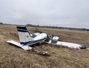 reported aircraft emergency in Sussex County on Tuesday.
According to the fire company, the incident occurred at the Delaware Coastal Airport near Georgetown and was reported at about 2:15 p.m. Upon arrival, first responders said they discovered that a small plane had skidded off of the runway and into a ditch. Fortunately, according to the Georgetown Fire Company, no injuries were reported.
The cause of the crash has not yet been specified by officials.
Sriwijaya Air Plane Suffers Tire Burst While Landing at SAMS Sepinggan Airport, All 128 Passengers Safe
Reporter: Chandra
Editor: Didik Eri Sukianto
BALIKPAPAN, NOMORSATUKALTIM - A tire burst incident occurred on a Sriwijaya Air plane with flight number SJY135, when landing at Sultan Aji Muhammad Sulaiman International Airport (SAMS) Sepinggan, Balikpapan, on Tuesday, February 17, 2026 afternoon.
The Boeing 737-500 aircraft with registration PK-CLH was on a route from Berau (BEJ) to Balikpapan (BPN).
According to information gathered by Nomorsatukaltim, this incident was first reported by a volunteer in Balikpapan, at around 15.49 WITA.
However, not long after, the plane that had experienced a tire burst was successfully evacuated along with all passengers.
Balikpapan's National Search and Rescue Agency (Basarnas) assisted with the evacuation process on the runway. Passengers were seen disembarking using manual stairs.
"Thank God, all passengers are safe and have been evacuated to the terminal," said the Head of Balikpapan Basarnas, Dody Setiawan briefly.
Responding to the incident, General Manager of PT Angkasa Pura Indonesia, SAMS Sepinggan Balikpapan Airport Branch Office, R. Iwan Winaya Mahdar, provided a detailed explanation regarding the handling of the incident.
He emphasized that the team's priority in the field is the safety and psychological recovery of service users.
"We can confirm that all 128 passengers are safe and well," said R. Iwan Winaya Mahdar, in an official statement on Tuesday, February 16, 2026 evening.
Iwan added that currently the passengers are in the SAMS Sepinggan Airport terminal area under the supervision of officers.
"Our main focus at this time is to ensure passenger comfort following the incident," he continued.
https://nomorsatukaltim.disway.id/amp/70511/pesawat-sriwijaya-air-mengalami-pecah-ban-saat-mendarat-di-bandara-sams-sepinggan-128-penumpang-selamat
NTSB Prelim: Beechcraft B300
Controller Subsequently Issued Multiple Low Altitude Alerts; However, There Received No Further Radio Communication
Location: Galveston, TX Accident Number: WPR26FA067
Date & Time: December 22, 2025, 15:05 Local Registration: ANX1209
Aircraft: Beechcraft B300 Injuries: 6 Fatal, 2 Serious
Flight Conducted Under: Armed Forces
On December 22, 2025, about 1505 central standard time, a Beechcraft B300, ANX1209, was substantially damaged when it was involved in an accident near Galveston, Texas. The pilot, co-pilot, two flight crew, two passengers were fatally injured and two passengers sustained serious injuries. The airplane was operated by the Mexican Navy.
Review of recorded communications between Houston Approach Control and flight crew revealed that at 2048:24, the flight crew established radio communications with the controller while enroute to the Scholes International Airport (GLS), Galveston, Texas. At 2048:38, the controller advised the flight crew that the approach into GLS would be vectors to final and queried if the flight was a medivac flight, to which the flight crew confirmed. At 2048:40, the controller advised the flight crew to turn 10° right, maintain 3,000 ft, vectors for the ILS. At 2048:49, the approach controller changed the approach clearance to the RNAV approach 14. At 2048:52, the flight crew responded with, “right and 10° right.” At 2049:18, the controller advised the flight crew to descend and maintain 3,000 ft and expect vectors for the RNAV. At 2049:26, the flight crew responded with, maintain 3,000, expect vectors to the runway.
At 2052:43, the flight crew queried the approach controller to determine which runway was in use. At 2052:54, the controller advised the flight crew, that RNAV 14 was in use, and that the GLS tower had advised the ceilings were 300 ft and queried the flight crew if they would like to continue with the approach, to which the flight crew responded with yes. At 2054:28, the controller instructed the flight crew to fly heading 310 descend and maintain 2,000, to which the flight crew responded with, “descend and maintain two three thousand, heading three one zero.” At 2054:42, the controller advised the flight crew, their assigned altitude is 2,000 and the heading was correct, which the flight crew acknowledged. At 2055:08, the controller advised the flight crew that in the event of a missed approach, fly 250 and maintain 2,000 followed by an acknowledgement from the flight crew. At 2055:42, the controller advised the flight crew to reduce speed to 170, which was acknowledged by the flight crew. At 2056:22, the controller advised the flight crew to turn left to a heading of 220 and the flight crew responded with, heading 220. At 2057:34, the controller advised the flight crew to fly heading 150, “to join,” which was acknowledged by the flight crew. At 2057:46, the controller advised the flight crew that because they didn’t make the turn, fly heading 100 “to join,” which the flight crew responded with 100.
At 2058:08 the controller advised the flight crew, once established they were cleared for the RNAV 14, and advised the flight crew a second time at 2058:40, they were cleared for RNAV 14. At 2058:49, the flight crew responded with, cleared to land runway one four. At 2058:53, the controller advised the flight crew that they were not cleared to land, that they were cleared for the RNAV. At 2059:02, the controller advised the flight crew that they were cleared for the RNAV, they were not cleared to land. At 2059:09, the controller advised the flight crew to contact the tower, which was acknowledged by the flight crew. The controller subsequently issued multiple low altitude alerts; however, there received no further radio communication from the flight crew.
Recorded ADS-B data provided by the Federal Aviation Administration (FAA) showed that flight track started about 13 miles northeast of the Merida International Airport (MMMD), Merida, Mexico at 1854:42, the airplane was on a northwest heading, at an altitude of about 12,025 ft mean sea level (msl). The airplane continued to climb to an altitude of about 27,500 ft. At 2034:49 the airplane continued on a northwest heading and initiated a decent to about 3,000 ft msl. At 2049:03 the airplane made a turn to a north – northwest heading and continued to descend. At 2056:39, at an altitude of about 1,950 ft msl, the airplane made a left turn to a southwest heading, consistent with radar vectors for the GPS 14 approach to GLS. At 2057:59, at an altitude of about 1,950 ft msl, the airplane made a left turn to a southern heading, consistent with radar vectors to the final approach course for the GPS 14 approach. At 2059:31, the data showed that the airplane initiated a descent, until ADS-B contact was lost.
The last ADS-B target was at an altitude of 275 ft msl, about 3 miles northwest of GLS.
Witnesses near the accident reported hearing an airplane over flying their location. One witness reported that, he heard the sound of the airplane’s engine “pull back” and then go to full power as if they were going to attempt a go-around before the sound stopped. Other witnesses who were on a boat, briefly heard, and then saw the airplane overfly their location, followed by a sound consistent with the airplane impacting the water. Numerous witnesses reported that the weather conditions at the time of the accident was fog with limited visibility. Recorded weather for GLS at 2215, included wind from 100° at 5 knots, visibility of ¼ statute mile, vertical visibility at 200 ft above ground level (agl), temperature of 69°F and dew point temperature of 69°F, altimeter setting of 30.21 inches of mercury.
Local law enforcement searched for and located the airplane wreckage about ½ mile from the Galveston shoreline in the waters of West Bay at a depth of about 5 to 10 ft. The debris path was oriented on a southern heading and was about 200 ft in length. The fuselage, both wings, engines and empennage were located within the debris path. The airplane was recovered from the water and transported to a secure location for further examination.
FMI: www.ntsb.gov

Today in History
8 Years ago today: On 18 February 2018 An ATR 72-200 operating Iran Aseman Airlines flight 3704 from Tehran to Yasuj, Iran, impacted a mountainside in the Mount Dena range to the northeast of Yasuj Airport. All on board were killed.
| Date: | Sunday 18 February 2018 |
| Time: | 09:32 |
| Type: | ATR 72-212 |
| Owner/operator: | Iran Aseman Airlines |
| Registration: | EP-ATS |
| MSN: | 391 |
| Year of manufacture: | 1993 |
| Total airframe hrs: | 28857 hours |
| Cycles: | 28497 flights |
| Engine model: | P&W Canada PW126 |
| Fatalities: | Fatalities: 66 / Occupants: 66 |
| Other fatalities: | 0 |
| Aircraft damage: | Destroyed, written off |
| Category: | Accident |
| Location: | 15 km NE of Yasuj Airport (YES) - Iran |
| Phase: | En route |
| Nature: | Passenger - Scheduled |
| Departure airport: | Tehran-Mehrabad Airport (THR/OIII) |
| Destination airport: | Yasuj Airport (YES/OISY) |
| Investigating agency: | AAIB Iran |
| Confidence Rating: | Accident investigation report completed and information captured |
Narrative:
An ATR 72-200 operating Iran Aseman Airlines flight 3704 from Tehran to Yasuj, Iran, impacted a mountainside in the Mount Dena range to the northeast of Yasuj Airport. All on board were killed.
The flight departed Mehrabad Airport at 08:05 hours local time and climbed to the cruising altitude of FL210. At 09:22 the aircraft was over the Isfahan (IFN) VOR. The flight requested permission to descend from FL210 to FL170. This was approved by Tehran ACC. The flight followed Airway W114 from the OBTUX navaid to the Yasuj DVOR/DME. Minimum altitude on that airway is FL170. Minimum safe altitude (MSA) over the sector close to Yasuj Airport is 15500 feet.
Weather reported to the crew indicated a cloud ceiling of 15000 feet. Despite their clearance for FL170 and the MSA in the area, the crew subsequently selected FL150 as their target altitude.
The flight levelled off at FL150 at 09:28 hours and the de-ice & anti-ice systems were switched on. Subsequently the flight crew selected the autopilot's altitude mode to FL150. The aircraft then entered a mountain wave with vertical (updraft) winds reaching up to 3000 ft/min with associated icing conditions. Since the autopilot attempted to maintain FL150, engine power reduced to flight idle and the aircraft pitched down -4°. In these conditions the speed gradually reduced from a Calibrated Airspeed (CAS) of 205 knots.
At 09:29:44 the flight crew switched off the de-ice & anti-ice systems. The aircraft then entered a mountain wave downdraft. Engine powered increased and the nose pitched up because the autopilot was attempting to get back to FL150. The CAS meanwhile dropped to 130 knots.
The pilot then selected FL140 on the autopilot as the airspeed dropped to 118 knots. The stall warning sounded and the autopilot disconnected automatically. Airspeed increased to 134 knots as the aircraft descended at a rate of -3200 ft/m. At 09:31:22 the flight crew re-engaged the autopilot and set FL150 as their target altitude.
Four seconds later the aircraft became close to the surrounding mountainous terrain and the EGPWS alarm sounded. Radio altitude at that point was 3643 feet (pressure altitude 13869 ft).
The autopilot was disengaged again as the aircraft continued to lose altitude. Unable to regain altitude the flight crew noticed the mountain side ahead rolled the plane -86° to the left. The nose pitched up and the aircraft impacted the side of a mountain at 09:31:41.
The wreckage was located the following day in the snow, 350 feet below the top of a 13,412 ft high mountain.
Probable causes (from final report):
The main cause of accident:
The accident was happened due to many chains of considered causes but the 'Human Factor' had main role for the conclusion of the scenario. The Cockpit Crew action which has caused dangerous conditions for the flight is considered as main cause. Based on provided evidences, the errors of cockpit crew were as follows:
- Continuing to the Yasouj airport for landing against Operation manual of the Company, due to low altitude ceiling of the cloud and related cloud mass. They should divert to alternate airport.
- Descending to unauthorized altitude below minimum of the route and MSA
- Lack of enough CRM during flight
- Failure to complete the stall recovery (flap setting, max RPM).
- Inappropriate use of Autopilot after Stall condition
- Inadequate anticipation for bad weather based on OM (Clouds, Turbulence, and Icing ...)
- Quick action to switch off anti-ice system and AOA
- Failure to follow the Check lists and standard call out by both pilots
Contributing Factors:
The contributive factors to this accident include but are not limited to the following:
- the airline was not capable to detect systematic defectives about :
- effectiveness of crew training about Meteorology, OM, SOP, ...
- enough operational supervision on pilot behaviors
- The lack of SIGMET about Mountain Wave or Severe Mountain wave
- Unclear procedure for stall recovery in FCOM
- Lack of warning in aircraft manuals by manufacturer for flight crew awareness about mountain wave.
- Lack of APM System to alert crew about performance degradation
METAR:
05:30 UTC / 09:00 local time:
OISY 180530Z 09004KT 9999 FEW035CB SCT040 OVC090 14/M01 Q1022
06:00 UTC / 09:30 local time:
OISY 180600Z 13004KT 9999 FEW035CB SCT040 OVC090 13/M00 Q1021
06:30 UTC / 10:00 local time:
OISY 180630Z 14006KT 9999 FEW035CB SCT040 OVC090 15/M02 Q1021