We start the new week and the month of March with these stories...
Of note, the rescue of two balloonists from their balloon/basket after becoming entangled several hundred feet up in a communications tower.
Be safe out there!
Tom
-
Crews work to bring down hot air balloon after it crashes into communication tower
The incident, which left two people trapped in the basket until they were rescued by first responders, has now entered a slow and technical recovery phase.
Author: CBS 19 Staff
LONGVIEW, Texas — A specialized tower repair crew spent Sunday securing and preparing to remove a hot air balloon basket that became lodged near the top of a 900‑foot cell tower after a dramatic crash Saturday morning.
The incident, which left two people trapped in the basket until they were rescued by first responders, has now entered a slow and technical recovery phase as crews work to safely dismantle what remains of the balloon and ensure the tower suffered no structural damage.
Nathan Wilson, a contractor with Tower King — the North Texas company brought in to handle the recovery — said Sunday’s work focused on rigging the tower so crews can begin lowering debris beginning Monday morning.
“We rigged the tower with wire rope from the ground up to the top,” Wilson said. “That’s going to allow us to safely handle all the material on the tower as well as get men up and down.”
Wilson said wind was a factor Sunday, slowing movement on the tower but not stopping progress.
“The wind was somewhat of an issue today, but that’s pretty common with tower work,” he said. “You just take your time and mitigate any issues you come across as the day goes on.”
From the ground, the balloon basket looked still. But Wilson said at that elevation, subtle movement matters.
“It was catching some wind and doing some twists,” he said. “Maybe not quite what you’d think, but enough that we needed to secure it well.”
Crews lashed the basket to a tower leg multiple times both horizontally and vertically to keep it from shifting overnight. Wilson said securing the onboard propane tanks was a top priority.
Monday’s work will focus on bringing the basket — and the shredded remains of the balloon — down in sections using a pulley‑based rigging system.
“It’ll be an all‑day process,” Wilson said. “You can’t rush these kinds of things. We hope to make good progress, but we plan to get most of the materials off by the end of the day.”
Workers will use a man basket positioned on the tower to move materials down the steel wire rope system. Using cutting tools, they plan to remove the balloon’s fabric in sections, wrap and lash it tightly, and load it into the basket before lowering it to the ground.
Wilson emphasized safety, especially with the presence of fuel tanks.
“It’s not going to change the way we approach things,” he said. “We take material handling on a tower real seriously. We’re going to maintain 100% tie‑off with all the men and tether all materials during the whole process.”
Crews plan to resume operations around 7 to 7:30 a.m. Monday.
Once the balloon and basket are removed, Tower King crews will inspect the tower to determine whether the impact caused any damage.
Wilson said they expect the overall structure to be sound but noted that smaller components may have been affected.
“You might have some small, more delicate antennas that sustained damage,” he said. “But the tower structure itself seems to be in good condition.”
https://www.cbs19.tv/article/news/local/2-trapped-after-hot-air-balloon-crashes-longview-radio-tower/501-2e68ef00-523d-40a7-bfac-f76f720c4819
These are the first images of the plane crash in El Alto; there are injured people and money on the road.
El Deber
The plane veered off the airport runway and crashed onto Costanera Avenue, ending up at the Bolivia Bridge. It destroyed several cars. Money was scattered across the road.
On Friday afternoon, around 6:20 p.m., an aircraft crash occurred in the La Costanera area of El Alto, after a plane veered off the runway. The incident caused concern among residents and passersby.
The national fire commander indicated that at least 15 people have died.
The aircraft was completely destroyed . It was a C-130 Hercules, registration FAB-81, belonging to the Bolivian Air Force. The first images of the fuselage began circulating on social media minutes after the crash.
According to unofficial reports, the aircraft was carrying valuables ; however, there has been no official statement confirming this information. Some videos circulating online show people approaching the scene and, amid the confusion, collecting what appears to be money scattered around the area.
Fire crews arrived at the accident site and sprayed water on the aircraft due to the risk of a possible explosion.
As of 7:15 p.m., police officers had not been able to enter the area due to traffic congestion in various parts of El Alto.
Authorities have not yet issued an official report on the causes of the accident or on possible victims.
In addition, the El Alto area experiences hailstorms.
The banknotes being transported by the bank were "scattered" in the middle of the road, amidst puddles of water.
The area was gassed because the crowd of people prevented emergency units from working.
Boliviana de Aviación (BoA) reported that the aircraft is not part of its fleet.
More people are arriving at the accident site; police officers and officers are securing the area.
Human injuries and property damage have been reported. Witnesses indicate that at least a dozen vehicles were damaged.
Firefighters had to extinguish flames that broke out on the plane. They also sprayed water on people who tried to steal money from inside the aircraft.
The incident is still under investigation.
The injured are people of different ages. They are being taken to the northern hospital.
American Airlines flight makes emergency landing in Pensacola after cabin smoke reported
by Tiffany Bartholemew
PENSACOLA, Fla. -- Passengers on an American Airlines flight from Tallahassee to Dallas reported seeing smoke in the cabin and smelling what seemed like something burning before the jet made an emergency landing in Pensacola on Sunday morning.
FlightAware data showed the flight diverted into Pensacola just before 6 a.m.
WEAR News spoke with a passenger who said they were not told why the unscheduled stop happened yet.
Officials have been contacted for comment.
No further details have been released.
https://weartv.com/news/local/american-airlines-flight-makes-emergency-landing-in-pensacola-after-cabin-smoke-reported
No injuries after small plane slams into Harvey Airfield hangar
by KOMO News Staff
SNOHOMISH COUNTY, Wash. — A small two-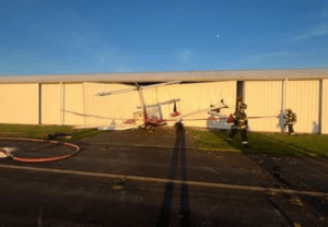 engine aircraft crashed into a hangar Saturday evening at an airport in Snohomish County, according to Snohomish County Fire District No. 4.
Firefighters were dispatched at 4:58 p.m. to a report of the crash. The first unit arrived at 5:06 p.m.
There were two people on board the plane. Both were uninjured and were able to exit the aircraft safely after the crash, officials said.
A second aircraft inside the hangar was damaged. Firefighters also contained a small gas leak using absorbent materials.
The airport remained open to other air traffic during the incident.
It is unknown what caused the aircraft to veer sharply off the runway.
The FAA and NTSB were notified, according to fire officials.
https://komonews.com/news/local/no-injuries-after-small-plane-slams-into-harvey-airfield-hangar-snohomish-country-airplane-crash-damage-hanger
Cessna veers off San Jose runway after landing gear collapse
By KTVU Staff
The Brief
-
- A Cessna aircraft veered off the runway at a San Jose airport Friday morning after its right landing gear collapsed during touchdown.
-
- The FAA confirmed the pilot was the only person on board and was not injured in the incident.
-
- First responders reported no smoke, fire, or hazardous leaks from the aircraft after it slid into a grassy area.
SAN JOSE, Calif. - A small aircraft veered off a runway in San Jose on Friday morning following a mechanical failure.
The Federal Aviation Administration told KTVU the plane’s right landing gear collapsed shortly after touching down at Reid-Hillview County Airport.
Pilot unharmed
What we know:
Authorities said the pilot was the only person on board and no injuries were reported.
After the gear collapsed, the aircraft slid off the runway and came to a stop in a nearby grassy area.
The San Jose Fire Department said there were no reports of smoke, fire, or hazardous materials leaking from the plane.
The Source: This story was written based on information from the FAA and the San Jose Fire Department.
https://www.ktvu.com/news/cessna-veers-off-san-jose-runway-after-landing-gear-collapse
Maiquetía: Emergency landing suspended operations this Friday
By Lubin Molero
The Simón Bolívar International Airport in Maiquetía was the scene of a critical air incident on the afternoon of Friday, February 27, when a Beechcraft A100 King Air aircraft, identified with the registration YV1306 , made an emergency landing .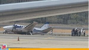
The incident originated from a mechanical failure in the landing gear , which forced the pilot to maneuver erratically upon touching down, generating the immediate mobilization of the Aeronautical Firefighters and the rapid response teams.
Small plane made an emergency landing in Maiquetía
Fortunately, the safety protocol worked perfectly: all occupants were unharmed and left the area without incident. However, due to the aircraft's position on the tarmac, airport authorities were forced to temporarily suspend all takeoffs and landings. The suspension remained in effect during the removal and cleanup operations to ensure the terminal's operational safety.
After the clearing maneuvers were completed and it was verified that the main runway had no structural damage, airport management reported that flight operations were fully restored starting at 5:15 pm. The incident caused a logistical rescheduling of domestic and international flights planned for the end of the day. The situation was quickly normalized under the supervision of the relevant authorities.
https://noticias24carabobo.com/avioneta-aterrizo-emergencia-maiquetia/
Updated: Pilot dies in plane crash near Utah-Arizona border
Written by E. George Goold
A 40-year-old female pilot from Boulder City, Nevada, died in a plane crash Saturday morning near the Utah-Arizona border, according to the Washington County Sheriff's Office.
“At 10:17 a.m. this morning, a call on dispatch said that a plane had crashed,” Sgt. Lucas Alfred told St. George News early Saturday afternoon.
Alfred added that the pilot of an aircraft flying nearby landed and went to check on the fallen aircraft and was the one who called 911.
That witness was the first on scene, Alfred said.
“They discovered a single occupant, an adult female, was found deceased,” Alfred said.
A news release from the sheriff's office added, "To respect the privacy of the family, at their request we will not be releasing the name of the pilot."
"This investigation is still on going," the release continued, "and investigators with the FAA and the National Transportation Safety Board are on their way down to continue their investigation. Due to this, the exact cause of the crash is not available at this time. The plane was flying with others."
Alfred said when he mapped the location, the crash occurred southwest of Apple Valley on a mesa that overlooks Warner Valley.
“It was very, very close to the Utah-Arizona border,” Alfred said.
As per standard protocol, Alfred said, the Federal Aviation Administration was notified of the crash as well.
Hurricane Valley Fire & Rescue posted photos from the scene on its Facebook page and provided additional details, saying "Paramedics confirmed that the sole occupant of the aircraft was deceased."
"Brush 41, Medic 43, and Battalion 44 responded to the incident, along with personnel from the Bureau of Land Management, Utah Department of Natural Resources, and the Washington County Sheriff’s Office."
This report is based on statements by law enforcement personnel and may not include the full scope of the findings.
Ed. note: Story and photos updated with information from Hurricane Valley Fire & Rescue, 4:45 p.m., Feb. 28, 2026. An additional update was made at 5 p.m., adding photos and pilot data from the Washington County Sheriff's Office.
https://www.stgeorgeutah.com/news/sheriffs-office-single-occupant-of-plane-dies-in-crash-southwest-of-apple-valley/article_8ad1b499-ac3e-4b9c-a16a-6db4c0599c0b.html
UPDATE: Investigation Ongoing After Crashed Aircraft Located in Hollywood, Maryland With Single Occupant Deceased
Southern Maryland News Net
FINAL UPDATE PENDING INVESTIGATION FINDINGS @ 12:30 P.M. 2/28/2026: On Saturday, February 28th, 2026, at 9:08 a.m., police, firefighters and emergency medical services were dispatched to the Dorsey Park on Hollywood Road in Hollywood, Maryland, for the reported aircraft incident investigation.
St. Mary’s County Emergency Communications Center received one call reporting a small plane went down in the area of the park.
Firefighters from Leonardtown, Bay District,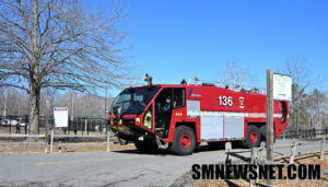 Hollywood, Second District, Seventh District, Solomons, and NDW Patuxent River responded to the area and began a command post at Dorsey Park, while others staged at the College of Southern Maryland awaiting search and confirmation information.
While crews searched McIntosh, St. Johns, Hollywood Road and the surrounding areas, St. Mary’s 911 Center received a 911 call from a citizen on Meredith Court reporting they think they saw a plane crash with the engine being heard go out.
Upon meeting with the 911 callers, First Responders gathered credible information with the aircraft believed to be downed between Hollywood Road and St. Johns Road, and began searching the areas with the help from citizens, ATV’s and other off-road vehicles.
Around 10:14 a.m., deputies with the St. Mary’s County Sheriff’s Office located the downed aircraft and began pinging his location for First Responders to respond to them.
At 10:21 a.m., Firefighters and emergency medical services arrived on the scene to confirm a small single engine aircraft had crashed into the wooded area, and confirmed a single occupant deceased inside the aircraft.
The incident remains under a joint investigation by the Maryland State Police, St. Mary’s County Sheriff’s Office, the NTSB, and FAA.
First Responders remind citizens if you see something, say something. As well as a huge thank you to the citizens who heard and saw something and called 911 and alerting them to make this recovery possible as this aircrafts flight was not on radar due to the aircraft being identified as an “ultralight aircraft” which does not require a tail number or beacon/transponder.
According to the FAA – ultralight aircraft that comply with FAA Part 103 regulations do not require registration, a tail number (N-number), a pilot’s license, or transponders/ADS-B equipment. These vehicles are generally restricted to single-seat operations, 5 US gallons of fuel, a top speed of 55 knots, and empty weight under 254 lbs. They must operate in uncontrolled airspace (Class G), stay below 10,000 feet MSL, and generally fly during daylight hours with visual contact with the ground.
Updates will be provided when they become available.
2/28/2026 @ 10:30 a.m.: First Responders have located the aircraft on private property off Hollywood Road approximately one mile into a wooded area
The small aircraft was occupied by one victim who has been confirmed deceased on the scene.
Investigation is ongoing and updates will be provided when they become available.
Expect extended delays on Hollywood Road.
2/28/2026 @ 9:30 a.m.: Dorsey Park on Hollywood road and College of Southern Maryland are being used as staging locations for fire and rescue personnel
Maryland State Police Aviation Command Trooper 7 is overhead conducting observation of the area.
No confirmation of any aircraft downed at this time.
ONGOING INCIDENT: First Responders from Calvert and St. Mary’s County are currently searching for a reported aircraft down in the Leonardtown / Hollywood area.
Updates will be provided as they become available.
Hollywood Road will have extended delays and possible closures
Pilot injured after small plane crashes in Burns Bog, Delta Police say
By Emma Crawford
The pilot of a small plane was taken to hospital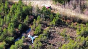 after the aircraft crashed into Burns Bog in Delta Saturday morning, according to police.
The Delta Police Department (DPD) says it was called to the area shortly after 10:30 a.m.
“The pilot was the lone occupant and suffered minor injuries,” the DPD said.
CityNews has reached out to BC Emergency Health Services for more information about the pilot’s condition.
Pilot injured after small plane crashes in Burns Bog, Delta Police say
NTSB Prelim: Grumman AA5
While The Airplane Was In Cruise Flight At 2,500 Ft Mean Sea Level, The Pilot Reported The Engine RPM Began To Increase And Then Decrease
Location: Admire, KS Accident Number: CEN26LA123
Date & Time: February 23, 2026, 09:58 Local Registration: N9939U
Aircraft: Grumman AA5 Injuries: 2 None
Flight Conducted Under: Part 91: General aviation - Personal
On February 23, 2026, about 0958 central standard time, a Grumman AA-5A airplane, N9939U, was substantially damaged when it was involved in an accident near Admire, Kansas. The pilot and passenger were not injured. The airplane operated under the provisions of Title 14 Code of Federal Regulations Part 91 as a personal flight.
The airplane was equipped with long-range fuel tanks and the pilot stated that on the day of the accident, he fully fueled the airplane and departed from the Ellington Airport (LUG), Lewisburg, Tennessee. Based on ADS-B data and pilot recollection, the airplane departed LUG about 0440 and flew to Kansas City Downtown Airport – Wheeler Field (MKC), Kansas City, Missouri, landing about 0825. After a brief stop, the airplane departed MKC about 0910 and headed towards Council Grove Airport (K63), Council Grove, Kansas. While the airplane was in cruise flight at 2,500 ft mean sea level, the pilot reported the engine RPM began to increase and then decrease. When the engine power began to decrease, and he switched fuel tanks, but was unable to restore engine power. He performed a forced landing to a field. During the forced landing, the landing gear collapsed, and both wings were substantially damaged.
The airplane was retained for further examination.
FMI: www.ntsb.gov
NTSB Prelim: Cessna 182G
Shortly After Takeoff, The Engine Lost All Power
Location: Quail Heights, FL Accident Number: ERA26LA116
Date & Time: February 16, 2026, 10:20 Local Registration: N515CL
Aircraft: Cessna 182G Injuries: 3 None
Flight Conducted Under: Part 91: General aviation - Personal
On February 16, 2026, at 1020 eastern standard time a Cessna 182G, N515CL, was substantially damaged when it was involved in an accident near Quail Heights, Florida. The pilot and two passengers were not injured. The airplane was operated as a Title 14 Code of Federal Regulations Part 91 personal flight.
The pilot reported that during the preflight inspection he added a small quantity of fuel to both wing tanks to ensure both were full, then sumped the wing tank drains and the fuel strainer, finding no contamination. Taxi out and runup were normal with no anomalies noted. Shortly after takeoff, the engine lost all power. The pilot decided to return to the airport and conducted a downwind landing opposite the direction of departure. After touchdown, he was unable to stop the airplane, and it overran the runway and subsequently impacted trees. The left wing and fuselage sustained substantial damage.
Post accident examination by the NTSB and FAA found no visible damage to the engine. Engine control continuity was established. Fuel was observed in both wing tanks, the carburetor bowl, and the fuel strainer, which also contained a small amount of particulate contamination. The upper spark plugs were removed and several exhibited sooting on the electrodes.
The wreckage was retained for further examination.
FMI: www.ntsb.gov
NTSB Prelim: Epic E1000
Main Wreckage (Found) At An Elevation Of About 8,175 Ft MSL. The Mountain Peak Is About 8,250 Ft MSL
Location: Steamboat Springs, CO Accident Number: CEN26FA115
Date & Time: February 13, 2026, 00:19 Local Registration: N98FK
Aircraft: Epic E1000 Injuries: 4 Fatal
Flight Conducted Under: Part 91: General aviation - Personal
On February 13, 2026, about 0019 mountain standard time, an Epic E1000 airplane, N98FK, was substantially damaged when it was involved in an accident near Steamboat Springs, Colorado. The pilot and three passengers were fatally injured. The airplane was operated as a Title 14 Code of Federal Regulations Part 91 personal flight.
According to on-board data collected at the accident site, the airplane departed from John C. Tune Airport (JWN), Nashville, Tennessee, about 1910 central standard time to Steamboat Springs Airport/Bob Adams Field (SBS), Steamboat Springs, Colorado, with a fuel stop in Kansas City Downtown Airport-Wheeler Field (MKC), Kansas City, Missouri. The airplane landed at MKC about 2053, was refueled, and departed to SBS about 2303.
According to preliminary air traffic control data, the pilot was given vectors to TILLI, which is the initial approach fix for both the RNAV Z RWY 32 approach and the RNAV – E approach to SBS. The controller cleared the pilot for the RNAV approach to SBS. The pilot acknowledged the clearance but replied, “RNAV 32 to Steamboat Springs.” The controller approved a frequency change to the SBS common traffic advisory frequency to which the pilot acknowledged. No further communications were received from the pilot. An Alert Notice was issued, and a subsequent search for the wreckage was initiated.
The wreckage was located in mountainous terrain about 3 miles south of SBS at an elevation of about 8,200 ft mean sea level (msl). A ground scar was found about 80 ft south of the main wreckage at an elevation of about 8,175 ft msl. The mountain peak is about 8,250 ft msl. The initial impact ground scars were aligned on an estimated 340° true heading. An odor consistent with jet fuel was present at the scene. Postaccident examination of the engine and airframe found no preimpact anomalies that would have precluded normal operation.
According to the Garmin G1000 data, the engine was producing about 1,700 propeller rpm (Np) and 92% gas generator speed (Ng). All recorded engine parameters were consistent with normal engine operation at the time of the accident. About 100 gallons of fuel remained at the time of the accident. The waypoints in the data were consistent with the RNAV Z RWY 32 approach. The minimum descent altitude for the approach is 9,100 ft msl. The last recorded altitude for the airplane was 8,221 ft msl, and the airplane’s autopilot was engaged. The RNAV Z 32 approach plate lists that the approach, both the circling and straight-in to runway 32, is not authorized at night. Additionally, the approach plate lists “Visual Segment – Obstacles.”
A review of SBS meteorological aerodrome reports revealed a report issued four minutes before the accident. At 0015, the wind was calm, visibility was 10 statute miles, and scattered clouds were reported 500 ft above ground level (agl), broken clouds 1,600 ft agl, and overcast clouds 2,400 ft agl. Data from FAA weather cameras installed at SBS was collected for further review.
According to FAA airman and operator records, the pilot held a commercial pilot certificate for airplane single-engine land with an instrument rating. He was issued a first-class medical certificate on October 22, 2025, and on the medical application, the airman reported 1,150 total flight hours.
At the time of the accident, there were two Notice to Airmen (NOTAMs) issued for SBS. One listed the runway end identifier lights (REIL) for runway 32 unusable. The other listed the Precision Approach Path Indicator (PAPI) lights for runway 32 unusable.
The wreckage was retained for further examination.
FMI: www.ntsb.gov
Today in History
63 Years ago today: On 2 March 1963 Philippine Air Lines flight 984, a Douglas DC-3, crashed into Mount Boca, Philippines, killing all 27 occupants.
| Date: | Saturday 2 March 1963 |
| Time: | |
| Type: | Douglas C-47B-30-DK (DC-3) |
| Owner/operator: | Philippine Air Lines |
| Registration: | PI-C489 |
| MSN: | 32863/16115 |
| Year of manufacture: | 1945 |
| Engine model: | P&W R-1830-90C |
| Fatalities: | Fatalities: 27 / Occupants: 27 |
| Other fatalities: | 0 |
| Aircraft damage: | Destroyed, written off |
| Category: | Accident |
| Location: | Mt. Boca - Philippines |
| Phase: | En route |
| Nature: | Passenger - Scheduled |
| Departure airport: | Cotabato-Awang Airport (CBO/RPMC) |
| Destination airport: | Davao City-Francisco Bangoy International Airport (DVO/RPMD) |
| Confidence Rating: | Accident investigation report completed and information captured |
Narrative:
Philippine Air Lines flight 984, a Douglas DC-3, crashed into Mount Boca, Philippines, killing all 27 occupants.
Flight 984 departed Cotobato at 09:40 for a 45-minute flight to Davao.
Nothing more was heard from the flight after a request for Davao weather. The plane was later found to have crashed into Mt. Boca at 3000 feet, 50 miles SE of Davao.
PROBABLE CAUSE: "The probable cause of the accident was due to navigational error, en-route and during let-down. Contributory factors were the limited visibility and the crosswind, all existing on the final phase of the flight."