This is all I have to close out the week...
Have a safe weekend!
Tom
-
2 people killed in Catalina Island plane crash, LA County Fire Department says
By Julie Sharp
A small airplane crashed in Avalon around 12:30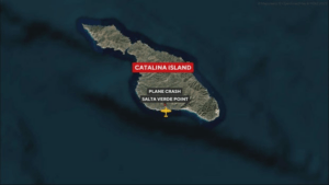 p.m. Thursday and the two people who were on board are dead, according to authorities.
The Los Angeles County Fire Department said the two-seater aircraft was last tracked at Salta Verde Point, on Catalina Island.
Baywatch Avalon and the Avalon Fire Department responded to the crash. Two people were dead at the scene, LACoFD said.
"This is a tragedy and my heart goes out to the loved ones of those who lost their lives," LA County Supervisor Janice Hahn said in a statement. "I am grateful to our paramedics and Sheriff's deputies who quickly reached this remote area and are handling this incident with professionalism and care."
The Catalina Island Conservancy said the plane crashed in a remote area southwest of the city of Avalon. The organization, which oversees the stewardship of the island's wildlife, said it has closed all hiking trails and roads near the crash site.
"We are deeply saddened to learn that two lives were lost in this incident and extend our heartfelt condolences to the families and loved ones of those on board," Catalina Island Conservancy said in a statement.
The FAA and the National Transportation Safety Board are investigating the cause of the crash of the Airplane Factory Sling.
https://www.cbsnews.com/losangeles/news/catalina-island-plane-crash-avalon/
NTSB Final Report: Honda Aircraft Co LLC HA-420
The Pilot Flying (PF) Elected To Continue To The Planned Destination Airport
Location: Orlando, Florida Accident Number: ERA24LA100
Date & Time: January 28, 2024, 16:23 Local Registration: N103JT
Aircraft: Honda Aircraft Co LLC HA-420 Aircraft Damage: Substantial
Defining Event: Loss of control on ground Injuries: 4 None
Flight Conducted Under: Part 135: Air taxi & commuter - Non-scheduled
Analysis: The on-demand air taxi flight proceeded to the destination airport and, about 1 hour and 22 minutes before landing, the flight crew reviewed the destination airport automated terminal information service (ATIS), which indicated the wind was from 270° at 14 kts, gusting to 24 kts.
The cockpit voice recorder (CVR) recorded the crew discussing the crosswind component of the winds reported on the ATIS, the aircraft operating limitations, company procedures, and an alternate airport, but the pilot flying (PF) elected to continue to the planned destination airport. About 16 minutes before the airplane touched down, when it was about 39 nautical miles (nm) from the destination airport, the PF advised the pilot monitoring (PM) that he checked the airport’s automated surface observing system (ASOS) and reported the wind velocity was currently at 270° at 13-14 kts. While on final approach, about 1.2 nm from the approach end of runway 36L, the tower controller advised that the wind was from 290° at 19 kts, gusting to 24 kts.
The PF continued the approach and just about when the airplane was at touchdown the controller broadcast on the frequency for another airplane that was on approach that the wind was from 290° at 20 knots, gusting to 24 kts. After the airplane touched down, it began drifting to the left side of the runway. The PF applied left aileron control input, deployed the speedbrake, and applied right rudder; however, the airplane departed the runway and impacted a frangible runway distance-remaining sign. The PF then corrected the airplane to the right, returned it to the runway, and taxied off onto a taxiway, where the pilot stopped the airplane and evacuated.
Postaccident inspection of the airplane revealed substantial damage to the left wing’s forward spar in the area that impacted the sign. The rudder and aileron trims were found in the neutral position. The operator reported there was no preimpact mechanical failure or malfunction with the airplane that would have caused the runway excursion. Although the PF reported about 16 minutes before touchdown that he received the ASOS observations for the previous 20 minutes and stated to the PM that the crosswind was at 13 or 14 kts, with the wind from 270° at 13 kts, a review of the 14 previous 5-minute ASOS observations revealed that gusts were reported in all but 2 of the 14 observations. The PF’s reference specifically to the wind being from 270° at 13 kts corresponded to an observation that also reported gusts to 24 kts, which occurred about 23 minutes before the airplane touched down. That gust value exceeded the airplane’s published crosswind limitation of 20 kts.
The gust values at the destination airport consistently exceeded the airplane’s published crosswind limitation for the majority of the 5-minute ASOS observations in 1 hour 23 minutes preceding the accident. These conditions should have necessitated either an earlier diversion to an alternate airport that was more aligned with the wind or a go-around during short final approach after the flight crew was informed, when the airplane was about 1.2 nm from the runway threshold, that the wind was gusting above the published crosswind limitation. The PF chose to continue with the landing and, due to a crosswind gust, failed to maintain directional control of the airplane after landing. The PF also did not incorporate the gust values into the crosswind calculations about 16 minutes before the accident, which likely influenced his decision to continue the approach.
Probable Cause and Findings: The National Transportation Safety Board determines the probable cause(s) of this accident to be -- The failure of the pilot flying to maintain directional control after touchdown with wind gusts that exceeded the airplane’s crosswind limitation. Contributing to the accident were the flightcrew’s continued approach to the runway despite the consistent wind gust crosswind component that exceeded the airplane’s published crosswind limitation, and their incorrect wind gust crosswind calculation in flight.
FMI: www.ntsb.gov

Today in History
53 Years ago today: On 10 April 1973 Invicta International Airways flight 435, a Vickers Vanguard, impacted a mountain while on approach to Basel/Mulhouse Airport, killing 108 occupants; 37 survived the accident.
| Date: | Tuesday 10 April 1973 |
| Time: | 10:13 |
| Type: | Vickers 952 Vanguard |
| Owner/operator: | Invicta International Airways |
| Registration: | G-AXOP |
| MSN: | 745 |
| Year of manufacture: | 1962 |
| Total airframe hrs: | 16367 hours |
| Engine model: | Rolls-Royce Tyne 512 |
| Fatalities: | Fatalities: 108 / Occupants: 145 |
| Other fatalities: | 0 |
| Aircraft damage: | Destroyed, written off |
| Category: | Accident |
| Location: | 15 km S of Basel/Mulhouse Airport (BSL) - Switzerland |
| Phase: | Approach |
| Nature: | Passenger - Non-Scheduled/charter/Air Taxi |
| Departure airport: | Bristol Airport (BRS/EGGD) |
| Destination airport: | Basel/Mulhouse Airport (BSL/LFSB) |
| Investigating agency: | AIB |
| Confidence Rating: | Accident investigation report completed and information captured |
Narrative:
Invicta International Airways flight 435, a Vickers Vanguard, impacted a mountain while on approach to Basel/Mulhouse Airport, killing 108 occupants; 37 survived the accident.
The Vickers Vanguard was operating on a charter flight from Bristol (BRS) to Basle Mulhouse (BSL). After entering the Basle Mulhouse terminal area, the flight was cleared to continue to the BN NDB. Weather was poor at that time: cloud base at 120 m (390 feet) and a reported runway visual range of 700 (2300 feet) and 1300 m (4250 feet). On arrival at the BN beacon the crew were cleared to descend to 2500 feet and were asked to report over the MN beacon before making a 90 degree left hand turn to finals for runway 16. At 09:56 the crew reported at 2500 feet, followed by a position report of the MN beacon at 09:57:40. When on finals over the BN beacon, the crew reported turning outbound and said they would report at the MN beacon again for another approach. When the crew reported overhead the BN beacon again, the plane was in fact overhead the airfield, flying parallel to the ILS localizer beam. After 1,5 minute the aircraft began to overshoot, correctly making an initial turn to the west. The crew, now flying well south of the field, were instructed to report back over the MN beacon. When reporting over the MN beacon again, before it would have to turn left for finals, the plane was in fact overhead the BS beacon, a beacon located to the south of runway 16. At 10:11:25 the crew reported over the BN beacon on finals and was cleared to land. In fact the plane was now flying 3 miles South of the field and 1 mile west of the extended centerline. Two miles further on Basle ATC asked the crew "Are you sure you are over the BN?". The captain replied "I think I've got a spurious indication. We are on the LO... on the ILS now, sir". Half a minute later the captain radioed "BN is established on localizer and glide path; the ADF's all over the place in this weather." Last radio contact was when the captain reported at 1400 feet, to which ATC replied that the flight was probably to the south of the airport. At 10:13 the plane brushed against a wooded range of hills and crashed 15 km from the airport. The aircraft disintegrated, except for the tail section, were most of the survivors were found.
PROBABLE CAUSE: "A loss of orientation during two ILS approaches carried out under instrument flight conditions. The following factors contributed to the occurrence of the accident:
1) inadequate navigation, above all imprecise initiation of final approach as regards height and approach center-line.; 2) confusion of aids; and 3) insufficient checking and comparison of navigational aids and instrument readings (cross and double checks).
The poor reception of ht medium wave beacons and technical defects in LOC receiver No.1 and glide slope receiver no.2 made the crewÂ’s navigational work more difficult."
![]()