We close out the week with the following stories...
Have a safe weekend, especially those traveling to Chattanooga for the 2026 ARFFWG Annual Educational Symposium kicking off on Monday!
Tom
==
First responders, public exposed to toxic chemical after jet crash
The Detroit News
A fiery military jet crash that forced evacuations near Traverse City was carrying a highly volatile and dangerous chemical, the health care system that treated the pilot said Thursday night. 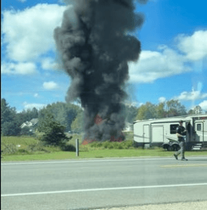
Munson Healthcare issued guidance Thursday night following the plane crash that exposed some to the chemical hydrazine.
"Due to the plane crash that took place in Blair Township earlier today, some first responders and community members were exposed to a hazardous chemical called hydrazine. As a result, Munson Medical Center has become the local decontamination site, utilizing an outdoor treatment area to evaluate and decontaminate individuals," the health system said in a Facebook post.
More: F-16 crashes in Grand Traverse Co. in fiery wreck
Munson said the "updated standard" for anyone who may want to seek a medical evaluation calls for only those within 1 mile of the crash who are symptomatic. Anyone within a mile of the crash site and are asymptomatic "should monitor for signs at home such as coughing, wheezing or trouble breathing, and come in if signs are present."
Hydrazine is a highly volatile fuel used as an emergency power source. The Air Force describes the chemical as highly toxic, flammable and corrosive. Exposure can harm the nervous and respiratory systems and, in severe cases, cause kidney damage or coma, according to the federal Centers for Disease Control and Prevention.
A Texas Air National Guard F-16 crashed Thursday in Blair Township during a training exercise, military officials said. The pilot was hospitalized and listed in stable condition. There were no other injuries.
More: Hazardous chemical spill in F-16 crash in Michigan prompts evacuation
Authorities issued a shelter-in-place order for an area along County Road 633. Residents were instructed to remain indoors and close windows and vents.
The shelter-in-place order was lifted earlier Thursday and the evacuation order was lifted Thursday night.
"The evacuation order has been lifted, and County Road 633 is now open," the Michigan State Police said in a 9:44 p.m. in a post on X. "Residents may now return to their homes near the plane crash site. Some residents of the Glacier Pond subdivision will not be able to drive to their homes at this time. You may park along the roadway and walk in as authorities continue to work in the area. Residents who cannot return home have been contacted by first responders directly.
https://www.detroitnews.com/story/news/local/michigan/2026/09/17/jet-crash-near-traverse-city-leads-to-this-toxic-chemical-exposure/91818951007/
Exploded power bank causes KLM flight to return to Amsterdam
Hans Hofstra
AMSTERDAM – A KLM flight from Amsterdam to Curaçao returned to Schiphol on Thursday afternoon. According to KLM, this was due to “technical issues”. A passenger on board reported to the editors of Curaçao.nu that a power bank had allegedly exploded during the flight. KLM cannot confirm this account at this time and will issue an official response later. 
UPDATE 2:55 PM (CURAÇAO) – KLM confirms that a power bank caught fire on board flight KL735 from Amsterdam to Curaçao. A KLM spokesperson stated that the crew acted in accordance with applicable regulations and extinguished the fire. Due to the incident, it was decided to return to Amsterdam.
Passengers are being rebooked. The delayed KL735 is expected in Curaçao on Friday, September 18, at 13:35. The return flight KL736 then departs at 15:50 and arrives at Schiphol on Saturday, September 19, at 06:55.
Previously reported
This concerns flight KL735 from Amsterdam to Curaçao, operated with a Boeing 777-300ER. According to flight data, the aircraft departed from Amsterdam later than scheduled and had already been en route for several hours when the decision was made to return.
Passengers told Curaçao.nu that, despite prior warnings, a power bank was reportedly used on board, after which it exploded. “The cabin crew quickly got the situation under control,” said a passenger. As a precaution, it was then decided to fly the nearly full flight back to the Netherlands.
No announcement on board
According to the passengers, no further details have yet been released regarding the precise cause and circumstances. Moreover, the flight was already delayed by approximately an hour and a half before departure, partly due to technical problems.
KLM has informed the editors of Curaçao.nu that the aircraft has returned due to technical problems, but that the airline does not yet have the full facts regarding the incident. An official statement will follow later.
The passengers of KL735 will be met at Schiphol upon their return. According to KLM, they will depart for Curaçao again on Friday. The intention is to use the same aircraft for this.
The return also has consequences for travelers who were scheduled to fly from Curaçao to Amsterdam on Thursday. They will be accommodated in Curaçao for one night and will depart for the Netherlands later.
One person dead in Lee County plane crash, sheriff's office says
The crash happened near Red Top Road in the Lynchburg area Thursday morning. The sheriff's office urges people to avoid the area or use caution.
Author: Christopher Buchanan
LEE COUNTY, S.C. — Lee County first responders are on the scene of a plane crash that happened Thursday morning, officials say. 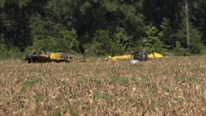
The Lee County Sheriff's Office said the crash occurred near Red Top Road in the county's Lynchburg area. Details were still limited at the time, but officials said the aircraft involved was a crop duster.
The Federal Aviation Administration (FAA) said the crash happened around 8:15 a.m. and involved a Weatherly 620B, which crashed into a field.
The sheriff's office said there was one person in the aircraft and that person is deceased. The county fire department, emergency medical services and the coroner's office are all on the scene. The FAA and the National Transportation Safety Board have been called in to further investigate the crash.
The sheriff's office urged the community to avoid the area if possible or otherwise use caution when traveling due to the emergency response.
This is a developing story. Check back for updates as they become available.
https://www.wltx.com/article/news/local/plane-crash-reported-lee-county/101-5b2f5ae5-f0b2-4b6f-a91f-ae5cefd56001
NTSB Final Report: Uvify IFO
Accident Occurred During The Initial Phase Of A 500 Small Unmanned Aircraft (SUA) Drone Light Show When Multiple Sua Failed To Achieve Proper Spatial Separation
Location: Orlando, Florida Accident Number: DCA25LA065
Date & Time: December 21, 2024, 18:35 Local Registration: UNREG
Aircraft: Uvify IFO Aircraft Damage: Substantial
Defining Event: Miscellaneous/other Injuries: 1 Serious
Flight Conducted Under: Unknown
Analysis: The accident occurred during the initial phase of a 500 small unmanned aircraft (sUA) drone light show when multiple sUA failed to achieve proper spatial separation, resulting in midair collisions and subsequent loss of control. Several sUA entered the audience which resulted in a serious injury to a spectator.
Drone show software (DSS) revealed that the uploaded show center position was incorrect resulting in an approximate 5-meter (16.4-ft) displacement from the intended location. This error caused the system to assign incorrect aircraft to flight paths. In addition, the show heading had not been entered correctly and was rotated by about 7°. These cumulative errors resulted in crossing paths and collisions during takeoff with flight paths closer to spectators than intended. Furthermore, when the show center location was updated only 498 drones were selected rather than 500, which resulted in 2 drones with different show center positions than the others.
Because the system relies on precise spatial alignment for deconfliction, these inconsistencies caused multiple sUA to converge during the initial climb, consistent with video evidence showing non-uniform liftoff followed by collisions.
The misalignment of the show heading resulted in the show flight position being off by about 18 meters or 59 ft, which moved the show closer to the audience. The policy for margin between the soft geofence and hard geofence had changed from 5 meters (about 16.4 ft) to 1 meter (3.28 ft)12 days before the accident. According to the operator, it was the responsibility of the remote pilot-in-command (RPIC) to update the command laptops with the new margin default setting as they were being used for shows. The data revealed that the geofence margin had not been updated and was set to 5 meters (16.4 ft). The combined errors resulted in a reduced safety area that was outside the company’s standards.
The FAA-issued certificate of waiver assigned responsibility for safe operations to management personnel. However, the operator lacked a formal requirement for independent verification of critical show parameters before launch. The absence of a robust cross-check or supervisory oversight allowed multiple configuration errors—including incorrect show center position, improper heading entry, inconsistent aircraft updates, and nonstandard geofence settings—to go undetected.
Probable Cause and Findings: The National Transportation Safety Board determines the probable cause(s) of this accident to be -- The remote pilot-in-command’s (RPIC’s) failure to locate the drone show center position over the physical location of the sUA, which resulted in multiple sUA colliding during the initial lift and subsequent loss of control. Contributing to the accident was the RPIC’s inappropriate geofence that was contrary to company procedures and an incorrect show heading which moved the show closer to the spectators. Also contributing to the accident was the operator’s lack of show oversight which allowed for multiple individual errors to go undetected before show start.
FMI: www.ntsb.gov

Today in History
80 Years ago today: On 18 September 1946 A Sabena Douglas DC-4 crashed while on approach to Gander Airport, Canada , killing 27 occupants; 17 survived the accident.
| Date: | Wednesday 18 September 1946 |
| Time: | 07:42 |
| Type: | Douglas DC-4-1009 |
| Owner/operator: | Sabena |
| Registration: | OO-CBG |
| MSN: | 42986 |
| Year of manufacture: | 1946 |
| Fatalities: | Fatalities: 27 / Occupants: 44 |
| Other fatalities: | 0 |
| Aircraft damage: | Destroyed, written off |
| Category: | Accident |
| Location: | 35 km SW of Gander, NL - Canada |
| Phase: | Approach |
| Nature: | Passenger - Scheduled |
| Departure airport: | Shannon Airport (SNN/EINN) |
| Destination airport: | Gander Airport, NL (YQX/CYQX) |
Narrative:
A Sabena Douglas DC-4 crashed while on approach to Gander Airport, Canada , killing 27 occupants; 17 survived the accident.
The DC-4 was on a flight from Brussels, Belgium to New York, USA, with intermediate stops at Shannon, Ireland and Gander, Newfoundland (now, Canada). The aircraft crashed in bad weather. Reportedly, the pilot attempted to carry out a visual approach to Gander by trying to descend below the clouds. Since the cloud base was about ground level, the airplane descended into trees. It crashed and broke up.
PROBABLE CAUSE: "The pilot did not carry out the appropriate approach procedure for landing in bad weather conditions."
