Here are your stories for today...
Be safe out there!
Tom
-
NASA plane makes belly landing at Ellington Airport, video shows
Viewer video captured a NASA research plane making a belly landing at Ellington Airport in Houston.
Author: Jaime E. Galvan, Jason Miles
HOUSTON — A NASA research aircraft made a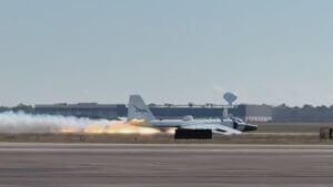 gear-up landing at Ellington Airport late Tuesday morning after experiencing a mechanical issue, according to NASA.
Cellphone video shared with KHOU 11 shows the aircraft skidding down the runway without its landing gear deployed, sparking fire and smoke as it slid to a stop. An aviation expert said the flames and smoke were caused by friction during the landing, noting the worst-case scenario would have been a post-landing fire.
According to a statement from Houston Airports, the incident happened around 11:30 a.m. as the aircraft was landing on Runway 17R–35L at Ellington Airport.
KHOU 11 crews arriving shortly after the hard landing saw two crew members exit the aircraft with help from emergency responders. One of the crew members appeared to visually inspect the plane before walking to an ambulance. NASA confirmed both crew members are safe.
What we know so far
NASA says a mechanical issue resulted in a gear-up landing involving one of its WB-57 aircraft.
Video shows the aircraft sliding along the runway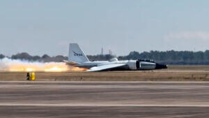 before coming to a stop, with emergency crews responding. Houston Airports officials say first responders with a military subcontractor handled the response. The runway where the aircraft remains was closed while crews worked to remove it.
No additional details about the mechanical issue have been released.
About the aircraft
The aircraft involved was a NASA WB-57 high-altitude research plane, based at NASA Johnson Space Center near Ellington Field.
The NASA WB-57 High Altitude Research Program operates three WB-57 aircraft out of Ellington Field. The WB-57 is a mid-wing, long-range research aircraft capable of flying at altitudes above 63,000 feet. It typically carries two crew members — a pilot and a sensor equipment operator — and is used for scientific and atmospheric research missions.
The aircraft can:
- Fly for about 6.5 hours
- Travel up to 2,500 nautical miles
- Carry up to 8,800 pounds of payload
- Reach airspeeds of about 410 knots
An aviation expert, John Celigoy, said NASA pilots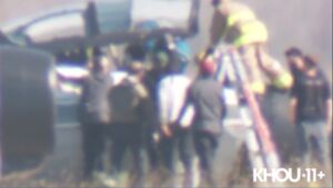 are among the best trained to handle emergencies, explaining that pilots are taught to flatten out the aircraft as much as possible during a gear-up landing to reduce impact.
He also said a landing gear failure can range from something as simple as a switch to a larger mechanical issue, such as a hydraulic pump. He added that the aircraft’s age may have contributed to a maintenance-related problem, though the exact cause remains under investigation.
What happens next
NASA says it will conduct a thorough investigation into the incident and will provide updates as more information becomes available.
Plane crashes into Payette River east of Emmett, killing two male passengers
By: KIVI Staff
EMMETT, Idaho — A plane crashed into the Payette River in the Black Canyon area east of Emmett on Tuesday morning, killing two male passengers, the Gem County Sheriff's Office confirmed.
One of the people on board the aircraft has been identified as Roland Steadham, also known for his role as Chief Meteorologist at CBS 2 Boise. The other victim has yet to be identified.
Investigators say the pilot struck a power line before crashing onto an icy section of the river.
In response to the incident, the Gem County Sheriff's Office and Gem County Fire & EMS were dispatched to the jet ski park turnout on the Payette River west of Montour. First responders remain on the scene at this time.
The plane crash also resulted in a significant power outage across the eastern portion of Gem County.
Highway 52 remains open, and the Gem County Sheriff’s Office is investigating the incident.
This is a breaking story, and we will continue to provide updates.
https://www.kivitv.com/news/local-news/in-your-neighborhood/emmett/plane-crashes-into-black-canyon-reservoir-near-emmett-downing-power-lines-in-the-process
Two pilots taken to hospital after single-engine plane crash in Bay Minette
by: Summer Poole, Debbie Williams
UPDATE (2:30 p.m.): Baldwin County Sheriff’s Office officials have released more information about a plane crash in Bay Minette on Tuesday.
According to a BCSO news release, deputies were called to the 12000 block of Airport Road just before 11 a.m. for a report of a single-engine airplane crash.
Deputies said they found two pilots walking toward the road from the crash site.
The pilots said the plane had engine failure during the flight.
One of the pilots attempted an emergency landing but couldn’t reach the airport due to “insufficient altitude.”
Officials said that both pilots had only minor injuries but were taken to Sacred Heart Hospital for evaluation.
PREVIOUS REPORTING
BAY MINETTE, Ala. (WKRG) — A pilot was injured after a Tuesday morning plane crash in Bay Minette.
The crash happened near the Bay Minette Airport, east of the runway, in a wooded area.
It happened just before 11 a.m. on Jan. 27.
The pilot has a cut on their head and ear.
https://www.wkrg.com/baldwin-county/plane-crash-bay-minette/
NTSB Opens Hearing On DCA Midair Collision That Killed 67
NTSB Says Both Pilots Had Difficulty Seeing Due To City Lights
The National Transpiration Safety Board opened a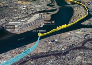 3-day hearing Tuesday to examine the January 2025 midair collision that killed 67 people, with investigators citing systemic failures across multiple organizations.
"It will not be an easy day," board member Todd Inman said. "There is no singular person to blame for this. These were systemic issues across multiple organizations." Limited visibility from Washington's city lights, windshield obstructions and a poorly designed helicopter route were among the key factors that contributed to the deadly mid-air collision between an Army helicopter and an American Airlines jet near Washington, D.C., last year.
The NTSB presented a cockpit visual simulation that indicates it was very difficult for both aircraft to see each other. In addition, the air traffic controller was described "as a little overwhelmed" at the time. The jet's pilot was not alerted about the helicopter; airspace in the nation's capital was crowded the night of Jan. 29, 2025; and warnings for years to reroute helicopter traffic were ignored.
NTSB members seemed troubled over missed opportunities and worried that additional disasters may occur if the government doesn't act on the investigation findings. "Are we going to sit here five years from now and say the data was there five years ago?" Inman asked, referring to staffing and training challenges at the airport. "We know people were raising the concerns, people were saying this was dangerous five, 10 years ago, and nobody was really listening."
NTSB chairwoman Jennifer Homendy said she couldn't believe the FAA didn't realize the helicopter route in use during the crash didn't provide adequate separation from planes landing on Reagan's secondary runway. She noted that the FAA had refused to add detailed information about helicopter routes to pilots' charts so they could better understand the risks. "We know over time concerns were raised repeatedly, went unheard, squashed - however you want to put it - stuck in red tape and bureaucracy of a very large organization," Homendy said. "Repeated recommendations over the years."
The Federal Aviation Administration last week made a permanent change to ensure helicopters and planes no longer share the same airspace around the airport. The NTSB will recommend additional action, and families of the victims say they hope there's meaningful change.
NTSB investigator Katherine Wilson said an air traffic controller felt a "little overwhelmed" when traffic volume increased to 10 aircraft about 10 to 15 minutes before the collision, but then "felt the volume was manageable when one or two helicopters left the airspace."
Yet about 90 seconds before the collision, Wilson said, "traffic volume increased to a maximum of 12 aircraft consisting of seven airplanes and five helicopters. Radio communication showed that the local controller was shifting focus between airborne, ground and transiting aircraft."
The workload "reduced his situational awareness," Wilson said.
FMI: www.ntsb.gov
NTSB Prelim: Airbus Helicopters EC 130 T2
“Aircom…LF1…We Have A Medical Emergency Onboard With Our Pilot…Uh Were Gonna…We Will Advise.” No Further Transmissions Were Received From The Flight.
Location: Lebanon, TN Accident Number: ERA26FA035
Date & Time: November 8, 2025, 13:41 Local Registration: N107VU
Aircraft: Airbus Helicopters EC 130 T2 Injuries: 1 Fatal, 2 Serious
Flight Conducted Under: Part 135: Air taxi & commuter - Non-scheduled - Air Medical (Medical emergency)
On November 8, 2025, at 1341 central standard time, an Airbus Helicopters EC 130 T2, N107VU, was substantially damaged when it was involved in an accident near Lebanon, Tennessee. The pilot and flight paramedic were seriously injured, and the flight nurse was fatally injured. The helicopter was operated as a Title 14 Code of Federal Regulations Part 135 air medical flight.
The helicopter, callsign "LifeFlight1" (LF1), was operated by Air Methods LLC. dba Vanderbilt LifeFlight as part of Vanderbilt University Medical Center’s (VUMC) critical care air medical transport service for VUMC and the Monroe Carell Jr. Children's Hospital. As part of the program, Air Methods provided all air transportation services and VUMC provided all medical staffing, patient care, and clinical services. The pilot was employed by air methods, and the flight paramedic and flight nurse, were employed by VUMC. The program had 8 bases. One of which was in Gallatin, Tennessee.
About 1334, LF1 departed from the Gallatin base in response to a launch request in Rutherford County, Tennessee. About 1337, the crew was informed by the operator’s communications center (AIRCOM) that the request had been cancelled. According to preliminary ADS-B data provided by the Federal Aviation Administration (FAA), shortly thereafter, the helicopter made a 180° turn back toward Gallatin. At the time, the helicopter was at an altitude of about 4,000 feet msl. A review of radio communications recorded by the operator’s communications center revealed that at 1339, they received a radio call from LF1 stating: “Aircom…LF1…we have a
medical emergency onboard with our pilot…uh were gonna…we will advise.” No further transmissions were received from the flight.
During a post-accident interview, the flight paramedic recalled that after receiving the cancellation from AIRCOM, the pilot turned the helicopter around. The flight paramedic acknowledged the cancellation via radio and advised that they were returning to base (RTB). After that point, he noticed that the pilot didn’t make any noticeable movements, which was unusual because typically, the pilots would nod or give a thumbs up to acknowledge. After he did not get confirmation from the pilot that they were turning around, the flight paramedic leaned forward and tapped the pilot on the shoulder. The pilot then looked at him and the flight paramedic said “Did you hear that? We are RTB.” He received no response from the pilot. He then asked the pilot if he was okay and saw that the pilot’s expression was a “complete blank stare.”
The flight paramedic recalled that around that time he remembered looking outside and thinking they were high. He then attempted to get the pilot’s attention several more times, but he did not receive a response. He further described that the pilot’s eyes were open, but there was no emotion. He saw that the pilot was trying to make an input into the GPS or possibly the autopilot, but he couldn’t put his finger on the button. The pilot was still not responding or making any purposeful movement of the flight controls. The flight paramedic then took off his restraints and leaned forward to see what the autopilot was doing. He did not see that the autopilot was engaged, and he realized that he needed to slow the helicopter down. The flight paramedic had never touched a cyclic control stick in flight before, as they were not allowed to, but from watching pilots’ hands in flight, he knew that small inputs would result in small reactions, and he needed a large reaction. He then grabbed the cyclic on top of the pilot’s hand, which remained on the cyclic, and pulled it back. The pilot did not resist this control
input. The helicopter responded much more than he was expecting, after which he made smaller inputs to slow down. He knew from watching pilots land that he had to decrease the power, so he also reached across the pilot’s lap and tapped down on the collective control because he knew that would slow them down.
The flight paramedic tried to get the helicopter into a level attitude and got to a point where it was slowing. The helicopter was in stable flight but still moving fast. There was a lot of farm land around, and the flight paramedic and the flight nurse were telling the pilot to land the helicopter. The flight paramedic pointed out a field to the pilot just left of their centerline. At this time the flight paramedic was out of his seat and kneeling over the console to reach the flight controls. The only coherent reaction he got from the pilot was when he acknowledged where the flight paramedic was pointing and said to him “there, no there…” and he pointed to a field further away and much more wide open. The flight paramedic then looked up and saw a bright yellow field lined with trees with descending terrain. While the flight paramedic was leaning over the console trying to control the helicopter, it struck the tops of the trees while
approaching the field. About 10-20 feet above the ground, the flight paramedic made a hard flare and the helicopter then impacted the ground.
The helicopter was last observed by ADS-B at 1341, at a GPS altitude of 775 feet, about 0.31 miles from the accident site. This was the helicopter’s last ADS-B-observed position. About 1345, personnel in the operator’s AIRCOM determined that the helicopter had “landed” at an unplanned location. AIRCOM then initiated the operator’s post-accident initiation plan, and received confirmation from emergency services in the vicinity of the accident site that the helicopter had been involved in an accident. The AIRCOM personnel also received a telephone call from the Air Force Rescue Coordination Center indicating that the helicopter's emergency locator transmitter had activated.
The helicopter impacted the ground and rolled on to its left side, coming to rest on upsloping terrain oriented on a magnetic heading of 275o. All major components of the helicopter remained intact with the wreckage. The crew and passenger compartment remained intact with the forward windshield being removed by first responders. The left door was open and bent back 180 degrees. The right and left sliding doors were intact but could not be opened due to crush damage by the skid step. Both skids remained attached to the helicopter and were compressed evenly. The left skid fractured in the center of the skid. The tailboom remained attached to the fuselage.
The tailboom was bent downward staring at the center about 10 degrees. The tail rotor driveshaft was separated at the center hanger bearing. The right horizontal stabilizer showed no signs of damage. The left horizontal stabilizer was bent upwards about 30 degrees. The Fenestron had damage to the underside of the Fenestron housing. All variable pitch rotor blades and fixed blades were attached and showed no signs of impact damage. The tail rotor gearbox showed no signs of damage.
The main transmission mounts were fractured and displaced from their attachment points. All three hydraulic servos remained attached to their lower attachment points and the non-rotating swash plate and pitch hors. The three main rotor blade retention pins remained installed and the main rotor blades remained attached to the blade grips. The main rotor head remained intact but exhibited impact damage. All three main rotor blades display damage consistent with being under power at the time of impact.
The engine data recorder information was downloaded and reviewed and showed no recorded abnormalities of the engine. The fuel system integrity remained intact with no apparent fuel leaving the fuel tanks. There was no postimpact fire. Overall, the postaccident examination revealed no evidence of any preimpact mechanical malfunctions or failure that would have precluded normal operation at the time of impact.
The pilot held an airline transport pilot certificate with ratings for rotorcraft-helicopter, airplane multi-engine land, and instrument airplane. He also held a flight instructor certificate with a rating for rotorcraft-helicopter. The pilot’s most-recent second-class medical certificate was issued by the FAA on May 17, 2025, with limitations relating to the use of corrective lens(es) to meet vision standards and that the certificate was not valid for any class after (its secondclass expiration). According to FAA airman records, the pilot had accrued 4,500 total hours of flight experience as of his most recent medical certificate application.
FMI: www.ntsb.gov

Today in History
24 Years ago today: On 28 January 2002 TAME Ecuador flight 120, a Boeing 727, impacted a mountainside while on approach to Tulcán Airport, Colombia, killing all 94 occupants.
| Date: | Monday 28 January 2002 |
| Time: | 10:24 |
| Type: | Boeing 727-134 |
| Owner/operator: | TAME Ecuador |
| Registration: | HC-BLF |
| MSN: | 19692/498 |
| Year of manufacture: | 1967 |
| Total airframe hrs: | 64001 hours |
| Cycles: | 49819 flights |
| Engine model: | P&W JT8D-9A |
| Fatalities: | Fatalities: 94 / Occupants: 94 |
| Other fatalities: | 0 |
| Aircraft damage: | Destroyed, written off |
| Category: | Accident |
| Location: | 27 km NW of Ipiales - Colombia |
| Phase: | Approach |
| Nature: | Passenger - Scheduled |
| Departure airport: | Quito-Mariscal Sucre Airport (UIO/SEQU) |
| Destination airport: | Tulcán Airport (TUA/SETU) |
| Investigating agency: | Aerocivil |
| Confidence Rating: | Accident investigation report completed and information captured |
Narrative:
TAME Ecuador flight 120, a Boeing 727, impacted a mountainside while on approach to Tulcán Airport, Colombia, killing all 94 occupants.
TAME Flight 120 was a scheduled flight from Quito to Cali, Colombia via Tulcán. The Boeing 727 took off from runway 17 at 10:03 for the first leg to Tulcán. The flight climbed to the cruising altitude of FL180 and proceeded on the G-675 airway towards Ipiales from where it was to turn to Tulcán. At 10:15 the flight contacted Tulcán Tower. At that moment the airplane was 29 miles from the Tulcán NDB. The crew received permission to descend to FL140 and was given the current weather information, which included 8000 metres visibility, few clouds at 200 metres and overcast at 500 metres. The approach procedure called for a speed of 180 kts, but the actual speed was much higher at 230 knots. During the descent the airplane flew into the side of the Nevado el Cumbal Volcano at 14,700 feet, 1400 feet below the summit.
PROBABLE CAUSE (translated from Spanish):
1) The decision of the instructor captain and his crew to initiate and continue the operation towards Tulcan airport below the meteorological minima established in the company's SOPs.
2) Inadequate navigation and operation of the aircraft by the pilot flying and directed by the instructor captain, consisting of entering the holding pattern of the Tulcan radio beacon with a speed of 230 knots indicated airspeed and with a banking of 15 degrees exceeding the maximum stipulated speed limit of 180 knots during the entire procedure including the holding pattern and using a banking below the recommended range of 25 to 30 degrees, thus exceeding the lateral navigation and obstacle protection limits of the holding pattern, leading this operation to the collision with El Cumbal Hill.