It's February! We start the new month and the new week with the following stories...
Be safe out there!
Tom
-
Small plane crashes in Brimfield Township, fire department says
By Ashley Pomplas and Michelle Nicks - WOIO
BRIMFIELD TOWNSHIP, Ohio (WOIO) - The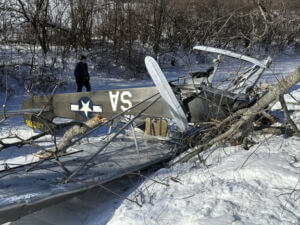 Brimfield Fire and Police Departments responded to a plane crash that occurred Sunday afternoon.
According to the Ohio State Highway Patrol, the crash happened at approximately 2:34 p.m.
OHSP said a Piper Cub two‑seat aircraft experienced an apparent loss of power and went down in a wooded area near 3222 Ranfield Road, west of State Route 44.
The Portage County Sheriff’s Office also responded to the scene.
Two occupants were on board of the plane and were initially evaluated on scene by Fire and EMS personnel.
They were transported to Cleveland Clinic Akron General and Akron Children’s Hospital with non-life threatening injuries, Brimfield Police said in a social media post.
According to a social media post from Brimfield Fire, the crash happened on Ranfield Road between Old Forge Road and Saxe Road.
The plane was actually built in 1944, that’s according the FAA Registry. That would make it over 80 years old.
The aircraft also has skis instead of wheels for landing gear. They help distribute the plane’s weight evenly and absorb impact during landings. They’re also designed to operate on unpaved and snow-covered surfaces.
Police said there are no reports of property damage or injuries on the ground.
According to Chief Investigator Robert Wain of the Portage County Coroner, they were not called to the scene for any fatalities.
An FAA inspector was heading to the scene and the crash remains under investigation.
19 News reached out to the plane’s owner in Wadsworth, who declined to comment on the crash at this time.
It remains unclear where the plane took off from and where it was headed at the time of the crash.
https://www.cleveland19.com/2026/02/01/plane-crashes-brimfield-township-fire-department-says/
Two injured after small plane runs off runway at Austin Executive Airport Friday night
by Will LeHardy
AUSTIN, Texas — Two people were injured after a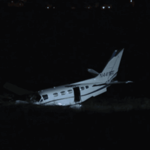 small plane ran off the runway at the Austin Executive Airport on Friday.
Austin-Travis County EMS confirmed that medics responded to a "small plane runway excursion" with two people aboard the aircraft on Friday evening at around 7:50 p.m.
Medics took two adult patients to St. David's Round Rock Medical Center with minor injuries. EMS says that the injuries were not life-threatening.
The Pflugerville Fire Department also responded to the call, AFD confirmed.
CBS Austin has reached out to the FAA and NTSB to learn more about the cause of the crash.
Response efforts underway after fuel spill at Hartsfield-Jackson airfield impacts river
Crews are working to determine the extent of the leak.
Author: Donesha Aldridge (11Alive)
ATLANTA — Hartsfield-Jackson Atlanta International Airport responded to a fuel spill impacting the Flint River. It caused at least one city to tell its residents not to consume the water as a precaution; that advisory has since been lifted.
According to an Atlanta airport spokesperson, efforts were underway Friday to mitigate the situation. The spill happened at the airfield.
"Response and cleanup efforts are underway, and environmental teams are on scene working with airport partners, the appropriate external agencies, and neighboring jurisdictions to manage the situation," the spokesperson said.
According to Clayton County Emergency Management Agency Director David Vazquez, around 8:30 a.m., county fire officials contacted the EMA about a potential spill at the airport on Clarke Howell Highway with possible exposure to the Flint River. EMA officials said they notified Clayton County Water Authority about the issue.
Around 11 a.m., EMA received another call about the situation, with representatives from the airport at the Upper Riverdale Road Bridge over the Flint River. Clayton County EMA said it also reached out to the Atlanta-Fulton County EMA, which then began an investigation into the situation.
"EMA met with a representative from the Airport and their contracted HAZMAT mitigation and clean up company," Vazquez officials said. "They are actively putting measures in place to contain the fuel and begin mitigation. Evidence of fuel was noticed in the river."
In addition, Vazquez said an EPD representative went to the next bridge at Valley Hill Road but didn't see contaminants in the river at that location. The Clayton County Water Authority said their water supply was tested and not impacted.
Crews are working to determine the extent of the leak.
"The Airport will continue to monitor conditions closely and share additional information as it becomes available," an airport spokesperson said.
Initially, the City of Griffin issued a Do Not Consume Water Advisory as a precaution. City officials said the initial information they received showed the spill hadn't reached the area of Griffin's water intakes, but they wanted to take precautionary measures out of an abundance of caution. The water advisory has since been lifted.
https://www.11alive.com/article/news/local/hartsfield-jackson-airfield-spill/85-576915be-d9c7-477a-aace-68327b77f452
FAA to undergo largest reorganization in agency history
New offices focus on safety, modernization, advanced technology
By Jay Wiles
The FAA will undergo a comprehensive reorganization according to a plan announced on January 26 by Secretary of Transportation Sean Duffy and FAA Administrator Bryan Bedford.
The reorganization includes creating several new divisions—many required by the FAA Reauthorization Act of 2024—including the Airspace Modernization Office to oversee the modernization of the national airspace system (NAS). That effort received an “unprecedented” $12.5 billion "down payment" last year and is strongly supported by AOPA and the rest of the Modern Skies Coalition, which is made up of more than 50 companies and organizations across the aviation industry.
“But funding is only one piece of the puzzle,” added Duffy. “With these critical organizational changes, the FAA can streamline the bureaucracy, encourage innovation, and deliver a new air traffic control system.”
The agency will also add a new safety oversight office, which “will implement a single safety management system (SMS) and risk management strategy for the entire FAA,” according to the announcement. “Now, instead of different safety metrics siloed in individual offices, the agency will be able to share safety data more freely.”
A third addition, the Office of Advanced Aviation Technologies, was also part of the latest FAA Reauthorization and will oversee the integration of drones, electric, and supersonic aircraft into the NAS.
Other changes include shifting key leadership posts to permanent positions and consolidating administrative functions under Bedford. The announcement said the reorganization “will not result in reductions in force.”
“It’s important that we have the right people in the right places to do the best work possible,” said Bedford. “These actions will put permanent leaders in place who embrace innovation, share safety data and insights freely and are focused on deploying a brand-new air traffic control system all while integrating key innovation technologies into the new National Airspace System.”
NTSB Points Fingers at FAA for ‘100% Preventable’ DCA Midair
Agency Says Numerous Warnings Were Ignored Leading Up to the Crash
The National Transportation Safety Board has confirmed the unfortunate reality that the January 2025 midair collision near Ronald Reagan Washington National Airport was “100% preventable,” citing years of ignored warnings about unsafe helicopter traffic near the airport.
The crash involved a PSA Airlines CRJ700 operating as American Eagle Flight 5342 and a US Army Sikorsky UH-60 Black Hawk. The CRJ was on final approach to Runway 33 when it crossed above Route 4: a path for helicopters along the Potomac River with a maximum altitude of 200 feet. At the same time, the Army helicopter, callsign PAT25, was flying that route at approximately 278 feet. The two aircraft collided over the Potomac River, leaving no survivors. 67 people lost their lives in the accident.
According to the NTSB, the key factor was “the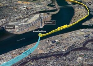 FAA’s placement of a helicopter route in close proximity to a runway approach path.” This routing left extremely limited vertical separation between helicopters and arriving airliners.
This was a known risk. The NTSB said the hazard had been formally identified as early as 2013, when a near miss at the same location drew attention to the small safety margin. The agency recommended that regulators relocate or eliminate Route 4 and marked the area as a known hazard on navigation charts.
Despite mounting concerns from local air traffic controllers and helicopter operators, the FAA decided to toss those recommendations. Charts continued to show the route without highlighting the minimal separation involved.
Investigators also pointed to broader issues that factored into the collision. Alerts from the Traffic Alert and Collision Avoidance System (TCAS) are blocked at low altitudes due to the presence of aircraft on the ground, breaching a last-ditch safety net. Controllers were used to frequent traffic alerts in the congested area and relied heavily on visual separation instructions instead. Staffing shortages and high arrival rates didn’t make matters any less complicated.
The NTSB’s latest update listed several additional contributing factors, including the Army crew’s failure to maintain visual separation, limited understanding of altimeter error tolerances, and the overall complexity of DCA’s airspace. Helicopter Route 4 has since been closed when Runways 15 or 33 are active.
FMI: www.ntsb.gov
NTSB Prelim: Bell Helicopter Textron 206L-1
Upon Touchdown, The Skids Teetered Aft, So He Brought The Helicopter To A Hover, Then Increased Power To Depart
Location: Kamas, UT Accident Number: WPR26FA082
Date & Time: January 18, 2026, 15:10 Local Registration: N138DD
Aircraft: Bell Helicopter Textron 206L-1 Injuries: 1 Serious, 3 Minor
Flight Conducted Under: Part 91: General aviation - Personal
On January 18, 2026, about 1510 mountain standard time, a Bell 206L-1, N138DD, was substantially damaged when it was involved in an accident near Kamas, Utah. The pilot and three passengers received minor injuries. The helicopter was operated as a Title 14 Code of Federal Regulations Part 91 personal flight.
According to the pilot of the 206L-1, he and another pilot planned to fly their respective helicopters to a mountain lodge for lunch. The other pilot was operating a Robinson R66 helicopter with two passengers onboard. Preliminary ADS-B data retrieved from a commercially available third-party source showed the 206L-1 departing from Skypark Airport (BTF), Bountiful, Utah about 1236. The pilots proceeded to Daniels Summit Lodge, Heber, Utah, where they arrived about 1300 and remained until about 1450. After departing the lodge, the flight-of-two proceeded to Wolf Creek Summit.
The R66 pilot stated he landed first in a large snow-covered area when they arrived at Wolf Creek Summit. According to the 206L-1 pilot, he prepared to land by conducting a power check and determined that the wind was light, and the helicopter had adequate power. The 206L-1 pilot then landed about 100 ft behind the R66. Upon touchdown, the skids teetered aft, so he brought the helicopter to a hover, then increased power to depart. While about 150 ft above ground level and above effective translational lift, the helicopter began to rotate clockwise about its vertical axis despite full application of left anti-torque pedal and lowering the collective. The helicopter impacted trees and descended to the snow-covered terrain.
Multiple videos, captured by witnesses near the accident site, recorded the helicopter in the air, rotating about its vertical axis before it impacted trees and descended to the ground. Postaccident examination revealed the helicopter came to rest on its left side on soft snow, surrounded by trees of about 40 to 50 ft in height, at an elevation of about 9,450 ft mean sea level. All major components remained on or near the main wreckage. The tailboom separated from the fuselage.
The aft end of the tailboom, that included the tail rotor gearbox and tail rotor assembly, separated from the tailboom. One tail rotor blade was about 50 ft from the main wreckage. The other tail rotor blade was not recovered. At least one main rotor blade fractured into multiple sections, while the other was partially buried in the soft snow.
The helicopter was recovered to a secure facility for further examination.
FMI: www.ntsb.gov
NTSB Prelim: Beech A36
ADS-B Data Showed That About That Time, The Airplane Entered A Rain Shower Followed By A Descending Right Turn Before Radar Contact Was Lost
Location: Sabine Pass, TX Accident Number: CEN26FA086
Date & Time: January 8, 2026, 14:31 Local Registration: N5677X
Aircraft: Beech A36 Injuries: 1 Fatal
Flight Conducted Under: Part 91: General aviation - Personal
On January 8, 2026, about 1431 central standard time, a Beech A36 airplane, N5677X, was substantially damaged when it was involved in an accident near Sabine Pass, Texas. The pilot was fatally injured. The airplane was operated under the provisions of Title 14 Code of Federal Regulations Part 91 as a personal flight.
The airplane departed the Jennings Airport (3R7), Jennings, Louisiana, at 1351, and was en route to the Scholes International Airport (GLS), Galveston, Texas, at an altitude of 6,000 ft mean sea level (msl). The pilot had filed an instrument flight rules flight plan and was in radio communications with Houston Terminal Radar Approach Control (TRACON). At 1430, the pilot was given a clearance to descend to 4,000 ft msl, which was acknowledged by the pilot. ADS-B data showed that about that time, the airplane entered a rain shower followed by a descending right turn before radar contact was lost. A U.S. Coast Guard crew subsequently found the wreckage in a marsh between Salt Lake and Knight Lake following a brief search.
The debris field consisted of four main sections which were distributed over an area about 360 ft long and 160 ft wide. The first section included the left wing and aileron that had fractured at the wing root. The second section included the outboard right wing separated near the mid spar and the right pilot’s seat. The third section included the propeller, engine, cowling, and cockpit instrumentation which were submerged in the marshy terrain. The final section included the aft cabin and empennage (see Figure 2). Smaller portions of doors, insulation, and aileron were located between the major wreckage areas. There was no evidence of fire. The flaps appeared to be in the retracted position.
The airplane was retained for further examination.
FMI: www.ntsb.gov
NTSB Prelim: Piper PA-28-140
Airplane Impacted Terrain In A Wooded Area About 693 Ft East Of The Departure End Of Runway 18 At M41
Location: Holly Springs, MS Accident Number: CEN26FA093
Date & Time: January 18, 2026, 16:40 Local Registration: N6711J
Aircraft: Piper PA-28-140 Injuries: 2 Fatal
Flight Conducted Under: Part 91: General aviation - Instructional
On January 18, 2026, about 1640 central standard time, a Piper PA28-140 airplane, N6711J, was destroyed when it was involved in an accident near Holly Springs, Mississippi. The flight instructor and student pilot were fatally injured. The airplane was operated as a Title 14 Code of Federal Regulations Part 91 instructional flight.
According to the airport manager, the airplane had departed Holly Springs-Marshall County Airport (M41), Holly Springs, Mississippi, after doing several touch and go landings. There was no ADS-B data available for the accident flight.
The airplane impacted terrain in a wooded area about 693 ft east of the departure end of runway 18 at M41. The first identified impact point was a pine tree about 185 ft south of the main wreckage. The airplane struck numerous pine trees along the impact path. Five branches were located at the site varying from .75 to 2 in diameter with clean cut marks and black paint transfer consistent with the airplane’s propeller. No ground impact marks were found at the accident site. A post-impact fire consumed a large portion of the airframe. The flight instruments and flight controls were thermally damaged or destroyed. The manual flap selector was thermally damaged and was found in the full flap (40 degree) position. The fuel selector valve was selected to the right fuel tank position and functioned normally when tested with low-pressure air.
Flight control continuity was confirmed for the flight controls. The stabilator trim cables were continuous from the empennage to the forward cabin location. The stabilator trim actuator control rod was extended 1.6 in on the top side of the actuator, which was consistent with a partial nose up trim position.
The airplane was equipped with a Lycoming O-320-E3D reciprocating engine. The engine remained attached to the engine mount. The propeller assembly was partially embedded in soft dirt. Engine control cable continuity was confirmed from the firewall forward to both the mixture and throttle arms of the engine’s carburetor. The mixture was found halfway between lean and rich while the throttle arm was found at a partial power setting. The engine primer control was found within the wreckage in the forward and locked position.
The spark plugs were removed from their respective cylinders. The spark plugs had normal wear patterns, and the coloration was consistent with normal engine operation. The lower plugs on cylinder Nos. 1 and 2 were oil soaked consistent with the oil drained from each cylinder upon removal. The lower spark plug for cylinder No. 3 was found impact fractured below the ignition harness nut. Examination of each cylinder was completed with a borescope with no anomalies found. Thumb suction and compression was confirmed on all cylinders by rotating the propeller in the direction of engine rotation. With all rocker box covers removed, all rocker arms moved freely and through their full range of motion with no anomalies found.
The oil lines to the oil cooler were found attached. The oil filter was found attached to the accessory section and safety wired but thermally damaged. The filter was removed, cut open, and inspected. The filter element had burned, but no metallic particles were noted between the remains of the filter pleats. The oil suction screen plug was found tight and secured to the oil sump with safety wire. Once removed, the screen was found free and clear of any debris. The oil filler neck was consumed by fire with only the metal dipstick remaining within the engine case. Oil was present in the oil sump, but total quantity was not determined.
Both magnetos were present, secure, and exhibited varying degrees of thermal damage to their aluminum housing. The magnetos were removed and an attempt to rotate them by hand was made. During the attempt, friction was present and both magnetos would bind during rotation. The left-hand magneto was disassembled, and thermal damage was noted internally. The right-hand magneto suffered a higher degree of thermal damage to its aluminum housing and was not disassembled.
The engine driven fuel pump was found attached to the rear accessory section of the engine and exhibited thermal damage. All fuel lines were found attached, but the aluminum housing showed signs of melting and deformation. During disassembly of the engine driven fuel pump, the gaskets and diaphragms were found thermally damaged. The fuel pump activation rod was found present within the accessory case and moved freely with rotation of the engine’s crankshaft.
The airplane was equipped with a Power Flow Systems Exhaust. The exhaust system was cut free from the engine at each cylinder and checked for blockage. The exhaust system was found free of any blockages or anomalies. All intake pipes were removed and found free and clear of blockage or debris.
The carburetor remained attached to the lower side of the engine. The airbox and air duct hoses were found impact or thermally separated. The carburetor was removed from the engine and examined. The float bowl was removed from the carburetor, and no fuel or fluid was found in the bowl. No sediment was present and the brass floats were free of damage or deformation.
The needle and seat were present. The seat was free and clear of any damage but showed discoloration consistent with thermal damage. The needle tip was deformed consistent with exposure to the post impact fire.
The propeller assembly was found partially embedded in the ground. Both blades remained attached to the propeller hub and the propeller was largely intact. The propellor exhibited slight thermal discoloration to one blade on the cambered side. No observable bending or deformation was noted to either blade. Slight chordwise scratches and smears were noted and consistent with cut pine branches found at the accident site.
The wreckage was retained for further examination.
FMI: www.ntsb.gov

Today in History
28 Years ago today: On 2 February 1998 Cebu Pacific Air flight 387, a DC-9-30, hit Mount Sumagaya, Philippines, killing all 104 occupants.
| Date: | Monday 2 February 1998 |
| Time: | 11:00 |
| Type: | McDonnell Douglas DC-9-32 |
| Owner/operator: | Cebu Pacific Air |
| Registration: | RP-C1507 |
| MSN: | 47069/175 |
| Year of manufacture: | 1967 |
| Total airframe hrs: | 73784 hours |
| Engine model: | P&W JT8D-7A |
| Fatalities: | Fatalities: 104 / Occupants: 104 |
| Other fatalities: | 0 |
| Aircraft damage: | Destroyed, written off |
| Category: | Accident |
| Location: | 45 km NE of Cagayan de Oro-Lumbia Airport (CGY) - Philippines |
| Phase: | En route |
| Nature: | Passenger - Scheduled |
| Departure airport: | Tacloban-D. Z. Romualdez Airport (TAC/RPVA) |
| Destination airport: | Cagayan de Oro-Lumbia Airport (CGY/RPML) |
| Confidence Rating: | Information is only available from news, social media or unofficial sources |
Narrative:
Cebu Pacific Air flight 387, a DC-9-30, hit Mount Sumagaya, Philippines, killing all 104 occupants.
Cebu Pacific Flight 387 departed Manila at 09:16 for a flight to Cagayan de Oro. The flight made an unscheduled stop at Tacloban at 09:53 to deliver some spare tires for another Cebu Pacific DC-9 (RP-C1506) stranded at Tacloban. The flight left Tacloban again after 9 minutes for a 61-minute flight to Cagayan de Oro. Last radio contact was at 10:48 while flying at FL115 over Claveria.
Local residents heard an explosion around 11:00 near the 8200 feet high Mount Balatucan. The aircraft was reportedly two miles off course when it hit the mountain.